What is Psychrometrics?
Psychrometrics is the study of the physical and thermodynamic properties of air-water mixtures (Gatley 2004; Knox et al. 2017; Kodama et al. 2001; Sherif 2002). A psychrometric chart is commonly used to establish variations in the environment based on changes in the air heat-moisture. Some terms used in psychrometrics are:
- Dry Air—Air containing no water vapor.
- Moist Air—A mixture of dry air and water vapor.
- Air Mixture—A mixture of dry air and water vapor.
- Dry Bulb Temperature—The temperature measured by an ordinary.
- Wet Bulb Temperature—The lowest possible temperature to which an air mixture can be cooled solely by the addition of water.
- Dew Point Temperature—The temperature at which moisture starts to condense from air cooled at constant pressure and humidity ratio.
- Humidity Ratio—Weight of water vapor in pounds per pound of dry air or grains of water vapor per pound of dry air or kilograms of water vapor per kilogram of dry air expressed as a decimal. This quantity may also be called Absolute Humidity.
- Relative Humidity (RH)—The ratio of actual water vapor pressure to the vapor pressure of saturated air at the same dry bulb temperature. RH is expressed as a percentage.
Reading a Psychrometric Chart
Learning how to read a psychrometric chart will help to understand how relative humidity and air temperature can be used to predict freezing and frost conditions and how it can be used as a tool to time the use of frost protection methods. In this introduction to psychrometrics, you will learn the relationships between dry bulb temperature, relative humidity, wet bulb temperature and dew point temperature; and how to use the chart and any two of these properties to determine the other two properties.
These properties are needed when you need to calculate 1) the time to turn your irrigation system on, 2) the time to turn your irrigation system off, and 3) the danger of frost damage (Parsons and Boman 2003). The psychrometric chart is used in many other calculations related to heating or cooling of the air (Kodama et al. 2001; Sherif 2002). For example, it is used for sizing air conditioning equipment (Sherif 2002).
The composition of atmospheric air is variable, particularly with regards to the amount of water vapor. The amount of water vapor in the air in Florida varies from around 1% by volume under cold dry conditions to above 5% during hot, humid summer months. Dry air has a defined composition of the following gases listed in Table 1.
A moist air mixture is defined as a mixture of dry air and water vapor. A psychrometric chart is a graphical representation of the thermal and physical properties of moist air. There is no set format for psychrometric charts and charts from different sources vary in format and in the parameters plotted on the charts. This publication primarily focuses on a chart specifically developed as a reference for managing the use of frost protection methods. The frost protection psychrometric chart deals with the relationships among dry-bulb temperature, wet-bulb temperature, dew point temperature and relative humidity. Other charts often deal with additional values including absolute humidity, specific volume and enthalpy.
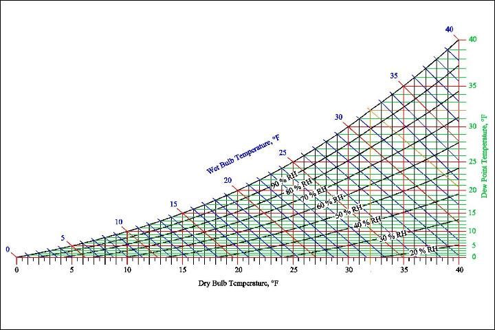
Refer to the psychrometric chart shown in Figure 1. The vertical lines along the chart represent "dry-bulb" temperatures, which are the temperatures measured by an ordinary thermometer. All points falling on a given vertical line will have the same dry-bulb temperature.
Example 1
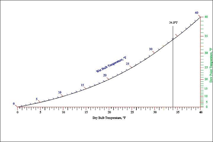
Locate the vertical line for 34°F dry-bulb temperature on a psychrometric chart (Figure 2).
Relative humidity is defined as the ratio of the partial pressure of water vapor present in a moist air mixture to the partial pressure of the water vapor that would be present if the moist air were completely saturated at the same temperature and pressure. Relative humidity is a measure of the amount of moisture that the air contains compared to the amount of moisture it would contain if it were saturated.
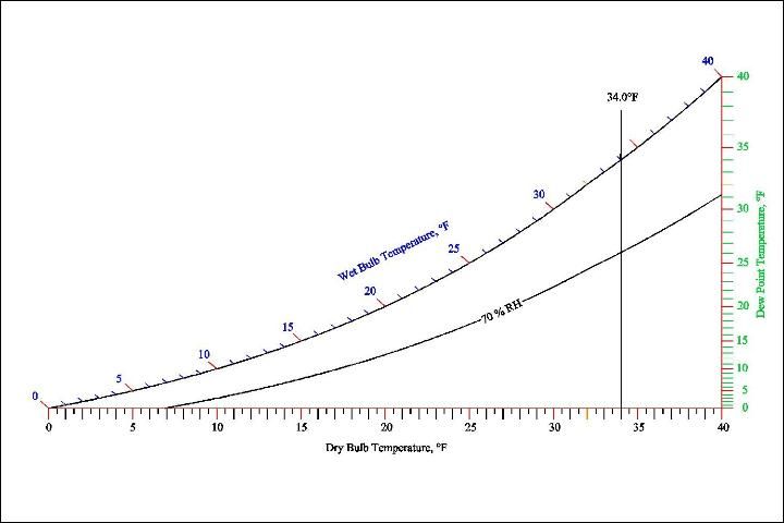
The curved lines that radiate from the lower left of the chart to the upper right are the "Relative Humidity" (RH) lines. The uppermost curved line is the 100% RH or "saturated" line.
Example 2
Find the intersection of the 34°F dry-bulb temperature vertical line and the 70% relative humidity curved line (Figure 3).
The wet-bulb temperature is defined as the lowest temperature to which an air mixture can be cooled solely by the addition of water. The process of cooling an air mixture with the addition of water and with no removal of heat is called "evaporative cooling."
The wet-bulb temperature is the temperature you feel when stepping out of a swimming pool when the wind is blowing. Under this situation, the skin temperature drops to the prevailing wet-bulb temperature of the air as long as the skin is covered with a thin film of water while exposed to a breeze.
The wet-bulb temperature is the lowest temperature that air can be cooled to by evaporative cooling. It is the wet-bulb temperature, not the relative humidity, that determines to what temperature air can be cooled by the evaporation of water. When using sprinkler methods for cold protection, it is important to remember that when sprinklers are first turned on, the air temperature will be cooled to the wet bulb temperature.
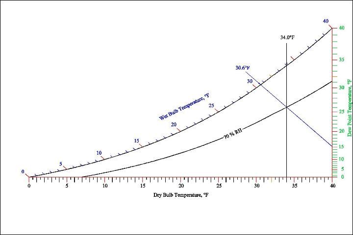
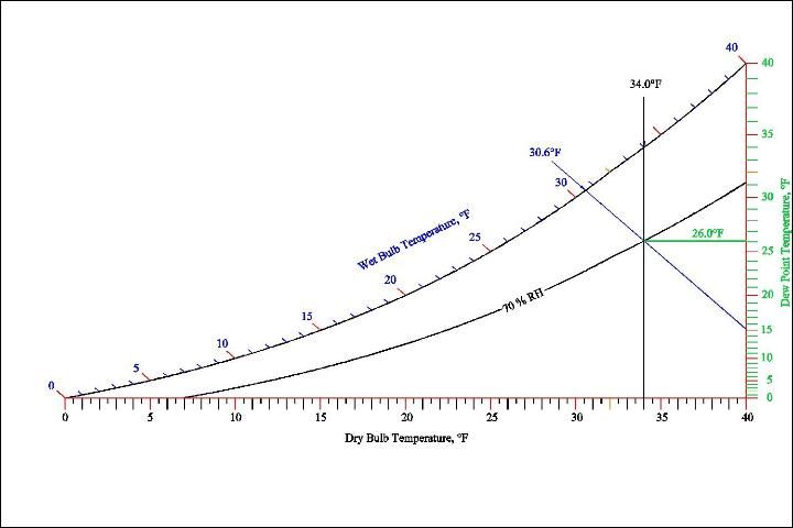
On the psychrometric chart, the wet-bulb temperature lines slope upward to the left. The psychrometric sketch in Figure 4 shows the wet-bulb temperature of a moist air mixture when the dry-bulb temperature is 34°F and the relative humidity is 70%.
The dew point temperature of a moist air mixture is the temperature at which condensation in the form of frost or dew first begins to form. Condensation will form on the outside of a glass tumbler filled with iced water because the temperature of the glass surface is lower than the dew point temperature of the air in the room. Therefore, some of the water vapor in the moist air mixture condenses on the outside of the glass tumbler.
Dew forms when the dew point is above freezing while frost forms when the dew point is below freezing. The dew point is closely related to the nighttime low temperature on still nights. When the air temperature drops to the dew point, energy is added back to the air as frost or dew forms and the temperature stabilizes at the dew point temperature. The dew point temperature is directly related to the actual quantity of moisture in the air and does not change much throughout a day unless a weather front moves through an area and adds or removes large amount of moisture. Therefore, the dew point temperature measured during daytime hours can be used as an estimate of the nighttime low temperature.
The charts shown in this publication list dew points on the right hand side. The dew point temperatures on some charts may be located on the saturation curve of the psychrometric chart. The psychrometric sketch in Figure 5 shows the general location of the properties we have covered.
Example 3
Determine the dew point temperature and wet-bulb temperature when the dry-bulb temperature is 38°F and the relative humidity is 65%.
Solution:
Dew point temperature is 27.8°F
Wet-bulb temperature is 33.8°F
Many psychrometric charts display a quantity known as the humidity ratio or absolute humidity. Humidity ratio lines are parallel to dew point temperature lines, make sure to read the dew point temperature scale, not the humidity ratio scale.
The four psychrometric properties of dry-bulb temperature, relative humidity, wet-bulb temperature and dew point temperature have been defined above. Given any two of these psychrometric properties, the other two properties can always be determined.
It is often necessary to interpolate between lines to estimate the value of a property of a moist air mixture. You should always be able to interpolate to at least 1 or 2% accuracy on the property values.
Example 4
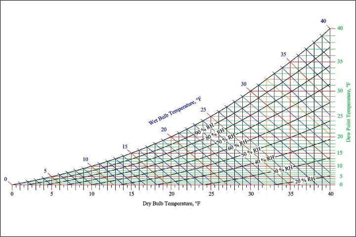
Use the chart (Figure 6) to find the following values:
(a) Find the wet-bulb temperature of a moist air mixture when the dry-bulb temperature is 36°F and the relative humidity is 30%.
(b) Find the wet-bulb temperature of a moist air mixture when the dry-bulb temperature is 36°F and the relative humidity is 90%.
(c) Determine the dry-bulb temperature of a moist air mixture when the relative humidity is 70% and the wet-bulb temperature is 35°F.
(d) Determine the relative humidity of a moist air mixture when the dry-bulb temperature is 37°F and the wet-bulb temperature is 33°F.
(e) Determine the dew point temperature of a moist air mixture when the dry-bulb temperature is 36°F and the relative humidity is 80%.
Solution:
(a) 27.3°F Wet Bulb Temperature
(b) 34.9°F Wet Bulb Temperature
(c) 38.7°F Dry Bulb Temperature
(d) 66% Relative Humidity
(e) 30.6°F Dew Point Temperature
Frost Protection
The dew point temperature and the wet-bulb temperature can be used to estimate the potential for frost and to determine the best time to turn on sprinklers for frost protection. Unless a weather front is causing cold air to move into an area, the nighttime low temperature is governed by the heat lost to the sky and the dew point temperature. The dry-bulb temperature falls at night as heat radiates to the sky. If enough heat is lost, the dry-bulb temperature will fall until it reaches to the dew point temperature. When the dew point temperature is reached, the dry-bulb temperature stabilizes as moisture starts condensing from the air in the form of dew or frost. Therefore, if you know the dew point, you can estimate the lowest possible night time low air temperature. However, it is always important to remember that plants can be cooled to temperatures lower than the air temperature by radiation losses from plant surfaces particularly during clear nights with low humidity.
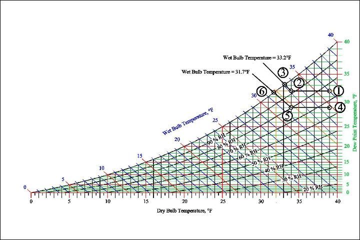
Plants can be protected from frost damage using sprinkler methods, but sprinklers must be turned on at the correct time to avoid cold damage by evaporative cooling and to conserve water. When sprinklers are first turned on, the air around the sprinklers will be cooled to the wet-bulb temperature. If the wet- bulb temperature is below 32°F, then cold damage can result from the use of the sprinkler system. The correct method is to start the sprinklers when the wet-bulb termperature is at 34°F to avoid damage to plants.
Sprinklers can be started at wet-bulb temperatures above 34°F, however, no additional cold protection will be provided, and excessive water will be used.
Example 5
The chart in Figure 6 illustrates how psychrometric charts can be used to manage frost protection methods. Figure 6 shows the effects of turning sprinklers on at a dry-bulb temperature of 34°F for two dew point (higher and lower) conditions. For both conditions, as heat is lost from the air, the dry-bulb temperature drops along a path following a constant dew point line until sprinklers are turned on at Points 2 and 5. After sprinklers are turned on, the dry-bulb temperatures drop along constant wet-bulb lines until the air is saturated at the 100% relative humidity line. For the first condition starting at Point 1, the air around the sprinkler will be cooled to 33.2°F and plants will be safely protected; however for the second condition, starting at Point 4, the air will be cooled to 31.7°F and plants could suffer cold damage.

Psychrometric Chart
The Psychrometric Chart (Figure 7) is for your use.
References
Gatley, D. P. 2004. "Psychrometric Chart Celebrates 100th Anniversary." ASHRAE Journal 46, 16–20.
Knox, J. A., Nevius, D. S., and Knox, P. N. 2017. "Two Simple and Accurate Approximations for Wet-Bulb Temperature in Moist Conditions, with Forecasting Applications." Bull. Amer. Meteor. Soc. 98, 1897–1906. https://doi.org/10.1175/BAMS-D-16-0246.1
Kodama, A., Hirayama, T., Goto, M., Hirose, T., and Critoph, R. E. 2001. "The use of psychrometric charts for the optimisation of a thermal swing desiccant wheel." Applied Thermal Engineering 21, 1657–1674. https://doi.org/10.1016/S1359-4311(01)00032-1
Parsons, L. R., and Boman, B. J. 2003. Microsprinkler Irrigation for Cold Protection of Florida Citrus. Gainesville: University of Florida Institute of Food and Agricultural Sciences.
Sherif, S. A. 2002. "Overview of Psychrometrics." ASHRAE Journal 44, 33–41.