Watersheds of Florida: Understanding a Watershed Approach to Water Management
Introduction
Water is of primary importance to all life on earth. Freshwater is a finite resource, and managing freshwater requires an understanding of watersheds and a watershed approach. Both quantity and quality of water are important (in that order) for balanced beneficial and efficient agricultural, industrial, rural, and urban uses.
The National Water Program is a partnership of the US Department of Agriculture, the National Institute of Food and Agriculture, and the Land-Grant Universities. It creates and disseminates knowledge to work toward safe and reliable water sources that are the appropriate quality to meet the following needs:
-
Food and fiber production;
-
Human health, use, and economic growth; and
-
Maintenance and protection of natural environmental systems.
Localized water bodies (lakes, streams, canals, etc.) should be routinely monitored for sufficient flows, levels, and quality. But it is also critical to understand the water balance at a watershed scale (a regional and natural boundary for water flows) in order to develop and implement water policies and regulate water quantity and quality. Several countries, including the United States, have adopted the watershed approach to conserve and protect water resources.
This fact sheet provides information on watersheds and introduces the watershed approach and management concept as practiced in the US, with a focus on Florida watersheds in particular. This document also provides information on the basins, basin groups, and hydrologic units of Florida used by the Florida Department of Environmental Protection (FDEP) to implement watershed assessment, monitoring, and restoration programs.
What is a watershed?
The terrestrial portions of the Earth are made up of multiple watersheds with water draining into various down streams. We all live in a watershed. All communities and habitats exist within a watershed boundary. The term "watershed community" owes much to the work and philosophy of the geologist and explorer, Major John Wesley Powell (1834–1902). Powell envisioned that settlements in the expanding American West should be close to water and watersheds. He argued that an area's precious water resources would be more easily protected and more properly used by encouraging cooperative use. One of his most popular quotes describes a watershed as "that area of land, a bounded hydrologic system, within which all living things are inextricably linked by their common water course and where, as humans settled, simple logic demanded that they became part of a community" (US EPA 2012).
The United States Environmental Protection Agency (US EPA) defines a watershed as "an area of land where all of the water that is under it or drains off of it goes to a common waterway, such as a stream, lake, estuary, wetland, aquifer, or even the ocean" (US EPA 2011).
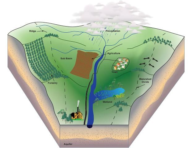
Credit: Greg Means
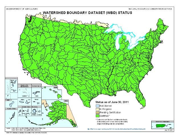
Credit: USDA-NRCS
Why is a watershed approach important?
Watersheds come in all shapes and sizes and are nested at different scales depending on where the point of converging flows is located. Watersheds cross regional, state, and national boundaries. An estimation of over $450 billion in food and fiber, manufactured goods, and tourism depends on clean water and healthy watersheds (US EPA 2011).
In order to optimize quantity and quality of our water resources, a watershed approach is the most effective framework. Watersheds not only supply drinking water and provide recreation, but also sustain livelihoods for the population living within their boundaries. Management of land directly and indirectly impacts water and other natural resources. Watersheds are highly connected, and this is well illustrated when various land uses upstream will directly impact the quality of water bodies downstream, regardless of political and property boundaries. It is critical that watersheds remain healthy for a vital economy and environment.
Watersheds form natural boundaries within a land mass and are geographically focused and hydrologically defined. They are the most logical building blocks for all water resource conservation programs. A sign of a healthy watershed is establishment of economically and environmentally sustainable livelihoods in a watershed. Using the watershed approach makes the focal point both water and other natural resources. It helps to strategically and comprehensively address resource priorities across the populations living in the watershed, integrating multiple programs based on sound science. Adaptive management for effectiveness and timeliness is fundamental to the watershed approach, providing flexibility to respond to dynamically changing situations and events.
How are watersheds identified?
Watersheds in the United States and the Caribbean were delineated by the US Geological Survey based on surface hydrologic features. Watersheds are currently grouped into four hydrologic unit tiers. Each hydrologic unit is identified by a unique hydrologic unit code (HUC) consisting of two to twelve digits based on the six levels of classification. A hydrologic unit, also referred to as drainage area, comprises the area of land upstream from a specific point on the stream that contributes surface water runoff directly to that outlet point. It is delineated by starting at a designated outlet point (usually the river mouth) and then following the highest elevation of land that divides the direction of surface flow, referred to as the ridge line. The boundary follows the basin ridges until connected back at the outlet point. The HUC classification codes are as follows:
-
2-digit HUC first level (Region)
-
4-digit HUC second level (Subregion)
-
6-digit HUC third level (Accounting Unit)
-
8-digit HUC fourth level (Cataloguing Unit—Sub-basin)
-
10-digit HUC fifth level (Watershed)
-
12-digit HUC sixth level (Sub-watershed)
The above sequence is better understood through the illustration in Figure 3, where the US is divided successively into a hierarchical pyramid structure of water-resource regions. The regions are arranged starting from the smallest (water-resources cataloging units) to the largest (water-resources regions). All areas have unique numbers that identify them. Two digits specify each individual area, and the numbers are progressively appended to specify the more detailed areas.
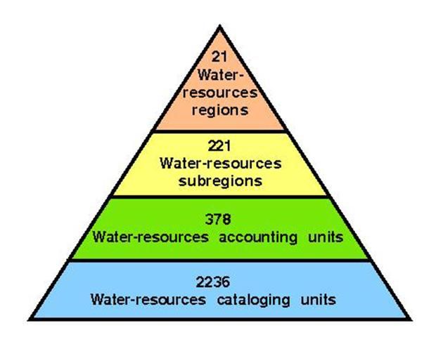
Credit: USGS
Delineations for the first four levels (2- to 8-digit HUC) have been completed and certified for the entire United States. The United States and the Caribbean are divided into 21 regions, 221 subregions, 378 accounting units, and 2236 cataloguing units. An important feature is the size of the watershed. The entire US territory is divided into 21 major geographic regions, with the mainland comprised of 18 regions. Alaska, the Hawaiian Islands, Puerto Rico, and outlying Caribbean areas form the other three regions (Figure 4 and Table 1). These numbers represent the first two digits of the HUC. The 21 regions are further subdivided into 221 subregions; they are represented by the third and the fourth digit of the HUC. Some watersheds (like the Mississippi River Basin) are very large and include many smaller river basins or watersheds. The smaller watersheds can be subdivided into even smaller areas. The United States Department of Agriculture—Natural Resources Conservation Service (USDA-NRCS) is presently developing a national system that will delineate, number (HUC), and name hydrologic units at a smaller scale (fifth level and sixth level). The US mainland and its territories are further grouped into water-resource regions as illustrated in Figure 4 and Table 1.
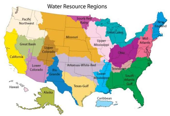
Credit: USGS
Watersheds of Florida
Florida has 52 large watersheds or basins based on the 8-digit HUC classification. Figure 5 and Table 2 contain details and an illustration of the Florida watersheds. Florida is part of the major sub-region of the South Atlantic Gulf watershed (two digit HUC-03). To help keep policy making and management consistent across programs, the FDEP has aggregated some of the 8-digit HUC classifications into 29 basins (Figure 6).
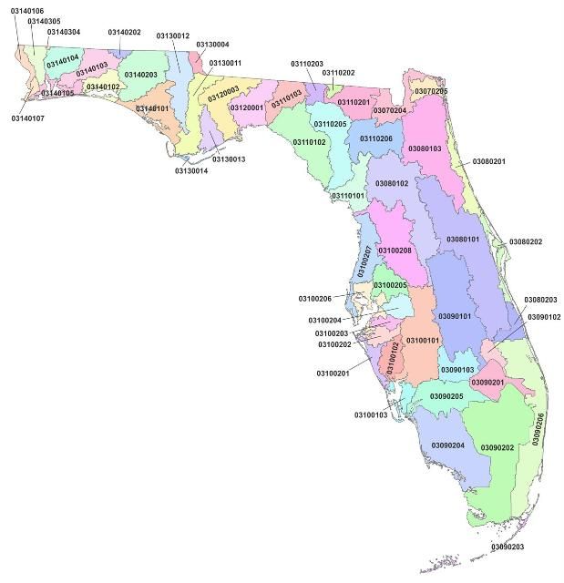
Credit: Greg Means
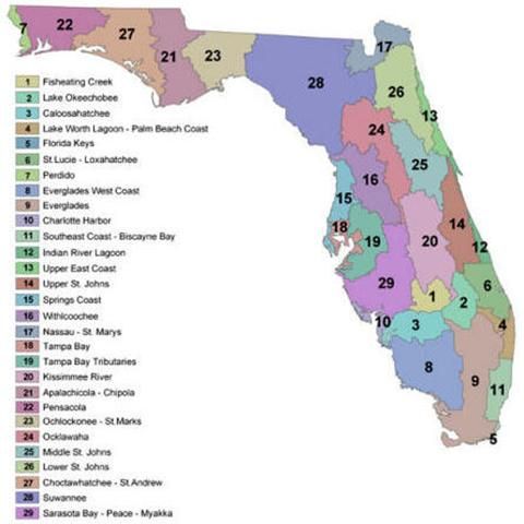
Credit: http://www.dep.state.fl.us/water/watersheds/
These 29 basins are further grouped into five major non-contiguous basin groups, numbered 1–5, based on the location of FDEP district offices for logistical purposes. These basins are used to establish and implement watershed activities and programs. FDEP uses a rotating basin cycle with the five basin groups over a five-year period as part of its water body restoration and watershed management program. That program includes work on watershed monitoring and data management, assessment, evaluation and Total Maximum Daily Load (TMDL) development, nonpoint source management and groundwater protection. Under these major steps, various aspects of watershed management are accomplished, including the following:
-
Surface water and groundwater monitoring programs and data integration
-
Assessment of impacts of wastewater facilities, industries, agriculture, septic tanks, urban development, etc., on surface water
-
Development of water quality restoration standards for impaired watersheds such as the Total Maximum Daily Loads (TMDLs)
-
Coordination of all activities among various partners and stakeholders through Basin Management Action Plans (BMAPs)
-
Administration of a grant program for implementing Best Management Practices (BMPs)
-
Storm water retrofits, etc., for minimizing contamination from diffuse pollution
-
Groundwater quality assessments
Additional information on the TMDLs and the Agricultural BMPs can be obtained from EDIS publication AE388/ABE362 Total Maximum Daily Loads and Agricultural BMPs in Florida (Migliaccio and Boman 2009; https://edis.ifas.ufl.edu/ae388). Also, more information on functions and management of watersheds can be obtained from EDIS publication AE265/ABE350 Watersheds – Function and Management (Shukla 2010; https://edis.ifas.ufl.edu/ae265).
Watersheds and Water Quality
Because watersheds are typically defined by the natural hydrology of an area, they represent the most logical basis for managing water resources. A watershed approach provides the ability to identify sources and transport pathways contributing to water quality or quantity and how the resources can be applied. This approach will reveal negative impacts from specific pollutants (such as excess nutrients from farmland, discharges from an animal facility, or discharges from a sewage treatment facility, etc.), alongside many other subtle and chronic stressors that affect the watershed quality, such as habitat destruction or polluted runoff. Such a comprehensive approach will help protect and restore impaired water resources effectively.
Water quality is defined based on the end use of the water resource (e.g., drinking, swimming, fishing, agricultural production, etc.). The standards used to protect the water quality for various parameters differ according to the designated end use. Traditional physical and chemical parameters of water quality include pH, nutrients, dissolved oxygen, suspended sediment, aquatic organisms, etc. Complementary water quantity guidelines also include discharge parameters (e.g., volume of peak flows), riparian conditions, and channel characteristics (e.g., width/depth ratios, habitat types, bed material, bank stability, and large woody debris). Overall health assessment of watersheds is fundamental to all monitoring programs.
Conditions in a healthy watershed operate within a range of dynamic equilibrium with one another. Management at the watershed level will help maintain a balanced range of conditions in between major reset events, such as significant hurricanes, floods, or droughts. A watershed approach can help avoid actions that would result in an imbalance or disequilibrium among the conditions in the watershed or would increase the frequency or severity of major reset events, as well as expedite recovery of the watershed health from such events. Major reset events will naturally occur, but appropriate and timely management will keep watersheds from becoming more susceptible to imbalance and stress.
Summary
Assessing the quantity and quality of water resources within each watershed boundary is important to protect and restore the health of the watershed. Although FDEP continuously conducts assessment, monitoring, and restoration by basin groups on a rotation basis, other governmental and non-governmental agencies work together to protect and sustain the quality of life within the watersheds. Everyone should know the watersheds and basins in the state because we all live in a watershed and directly contribute to its quality.
References
Florida Department of Environmental Protection (FDEP). 2011. "Watershed Management." Accessed June 21, 2012. http://www.dep.state.fl.us/water/watersheds/.
Migliaccio, K.W. and B. Boman. 2009. Total Daily Maximum Loads and Agricultural BMPs in Florida. ABE362. Gainesville: University of Florida Institute of Food and Agricultural Sciences. Accessed June 21, 2012. https://edis.ifas.ufl.edu/ae388.
Shukla, S. 2010. Watersheds - Functions and Management. ABE350. Gainesville: University of Florida Institute of Food and Agricultural Sciences. Accessed June 21, 2012. https://edis.ifas.ufl.edu/ae265.
United States Environmental Protection Agency (US EPA). 2011. "Our Waters." Accessed June 21, 2012. http://water.epa.gov/type/.
US EPA. 2012. "What is a Watershed?" Our Waters, Watersheds. Accessed June 21, 2012. http://water.epa.gov/type/watersheds/whatis.cfm.
United States Department of Agriculture – Natural Resources Conservation Service (USDA-NRCS). 2011. "Watershed Boundary Dataset Status." Accessed June 21, 2012. http://www.nrcs.usda.gov/Internet/FSE_MEDIA/nrcs143_021556.jpg.
