Introduction

As urban communities grow, design and management strategies for new developments become critical factors that determine impacts on natural resources. How can we accommodate growth and yet conserve natural resources, such as biodiversity, water, and energy? In this document, we focus on conserving biodiversity when land is subdivided. The term biological diversity or biodiversity refers to the variety of life and its processes. Biodiversity includes species diversity, habitat diversity, and genetic diversity. For the purposes of this article, we focus on biodiversity of native species. Native species are plants and animals that were present within a specific region before Europeans made first contact. Non-native (or exotic) plants or animals are species that were not present in the region before European contact.
Recently, a popular concept called clustered development or conservation subdivision has been advanced by the landscape architecture community. Conservation subdivision is intended to integrate growth with biodiversity conservation. Conservation subdivisions typically are developments where homes are clustered on small lots with the remaining areas conserved as open space.
The concept of conservation subdivision has gained traction in many planning and design fields. The goals for conservation subdivisions are twofold: 1) to improve biodiversity within a designated a subdivision; and 2) to minimize development-related impacts on surrounding habitats. Often, though, most of the effort is on the design of the entire site. To conserve and improve biodiversity within urban environments effectively, one must consider the following three phases of development: design, construction, and post-construction.
The design phase is typically where, among other aspects, lot size and open space are designated, and roads are distributed throughout the site. Goals for the development project are discussed and prioritized. In this phase, homes and lots are placed across the site and the remaining area designated as (natural) open space. Basically, everything is laid out on paper and vertical structures (i.e., buildings) and horizontal structures (i.e., roads, lots, conserved areas, and shared spaces) are given specific spaces within the development.
Next, during the construction phase, a whole host of built environment professionals (e.g., architects, contractors, and subcontractors) take whatever is on paper and implement this on the ground, constructing homes, streets, waste treatment systems, and landscaped areas (i.e., sections and parks). In the absence of fully trained or engaged contractors or landscapers, many things can happen during this phase that could impact the viability of onsite and nearby natural habitat. For example, even if the most important large trees are preserved across the subdivision and built areas are designed around them, the placement of topsoil and routes used by heavy construction vehicles could impair the survival of these trees. If heavy vehicles continually run over the root zone of a tree or if topsoil is placed against the tree trunk, the roots may not be able to acquire nutrients, water, and oxygen, and the tree may die.
In the final phase, post-construction, buyers purchase the homes, move into the community, and manage their own homes and sections, neighborhoods, and common areas. It is now the responsibility of residents to manage their homes, yards, and neighborhoods in ways that do not compromise the original intent of the community. Additional problems can arise if residents are not fully engaged—imagine residents moving in and planting invasive exotic plants in each of their yards. Residents could also improperly apply fertilizers and pesticides. The spread of invasive plants and stormwater runoff could then destroy or at least severely reduce the diversity of animals plants found in the conserved areas.
Overall, these three phases must be addressed in order to create and maintain biodiversity within residential subdivisions. A series of EDIS documents, titled "Conservation Subdivision," discuss biodiversity conservation pertaining to all three phases of development: design, construction, and post-construction. This fact sheet focuses on decisions made in the design phase. During the design phase, people consider what percentage of the site will be conserved as open space. This conserved open space could be any number of patch sizes and shapes. The purpose of this fact sheet is to present how one conserves open space according to ecological principles that maximize biodiversity values.
Conserve Natural Areas According to Ecological Principles
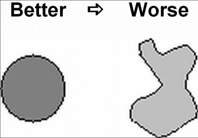
Patch size, shape, and connectivity are extremely important factors when determining which habitats to preserve for biodiversity. Below are some general design principles that address conserving or creating new habitat for wildlife species that are specialists. Animals that are specialists need a specific type of habitat. Declining wildlife species tend to be specialists (as opposed to generalists). Specialists do not do well in fragmented areas consisting of relatively small, isolated patches. Generalists are wildlife species that will eat just about anything and live in a variety of habitats. Think about house sparrows (Passer domesticus) and European starlings (Sturnus vulgaris). These exotic birds are found throughout many countries and are outside their natural range in Europe, but seem to do quite well in urban and agricultural areas. Specialists, on the other hand, are much more specialized in their food and shelter requirements. They will sometimes only eat a few types of food and live in only one type of habitat. They do not adapt well to changes in the habitat and will be extirpated (or go extinct) locally when their habitat changes. Examples from the US are most species that are listed on the US endangered and threatened species list (e.g., Florida scrub-jay, Aphelocoma coerulescens).
Typically, specialists require large patches of connected habitat. However, a planned subdivision may not have realistic opportunities to conserve connected, large patches of habitat. But the conservation of small patches of native habitat could also benefit biodiversity! Each of these small patches would not only contain many native plant species, but also could be used as habitat for a variety of native animals. In particular, small fragments could be used by generalist species and even specialists that temporarily use these patches for refuge when moving across the landscape. For example, some migrating birds would temporarily use native, small urban remnants for shelter and foraging opportunities. These urban remnants would serve as stopover sites that aid birds during migration and help them successfully complete their fall and spring trips. In addition, many insect species are very responsive to small patches of native habitat. Butterflies and even a variety of native bees are known to use native plants found in patches as small as a front yard! Thus, although the principles listed below focus on conserving connected, large patches of habitat, small disconnected patches of habitat also can be used to conserve biodiversity and should be recognized and conserved or restored.
The principles discussed below are centered on conserving wildlife populations, but conserving wildlife habitat also means conserving a diversity of plants. For example, more different plants are adapted to the edges of forested patches than are adapted to interior patches. A mixture of large and small patches would provide both interior and edge habitats and, therefore, would support a variety of plants. If a planned development were to have significant portions of conserved open space, the following ecological principles could be used to help select the sizes and shapes of conserved patches.

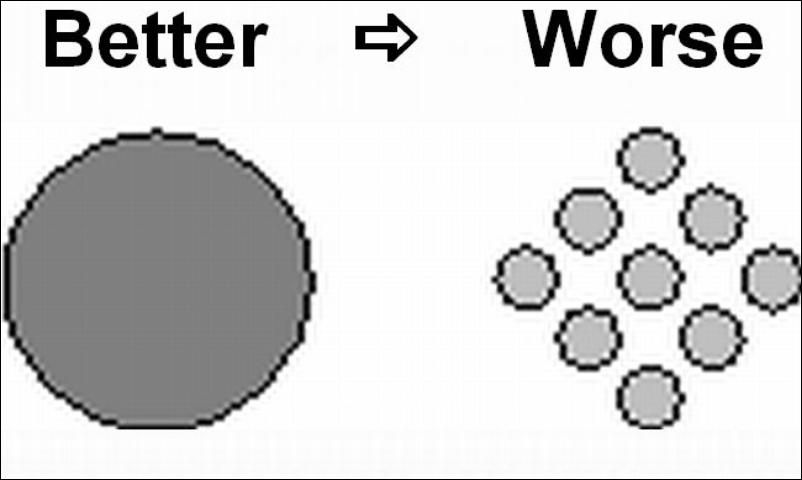
![Figure 3 Figure 3. Large patches are better than small. As a general rule, bigger patches tend to have more species. Many species, such as some forest songbirds, primarily live in interior habitat during the breeding season. Generally, interior habitat will begin to appear in a circular preserve when it reaches 8 acres [c. 3 ha] in area (the point at which a circle exceeds 328 feet [c. 100 meters] in radius). How much of a patch is considered edge? Estimates vary, but an edge is estimated to extend 50–100 meters into a patch of habitat. Essentially, microclimatic conditions (soil moisture, temperature, etc.) are different on edges vs. interiors. At 90 acres [c. 36 ha] a circular reserve would contain as much interior as edge habitat. Nevertheless, patch size requirements vary according to factors such as species and natural community type. Even conserving a collection of small patches can help threatened and endangered species.](/image/UW320/7297851/11986093/11986093-2048.webp)


Maintain Corridors
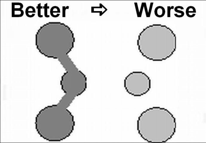
Whenever possible, efforts should be made to coordinate habitat preservation with adjacent landowners. This can help to create a matrix of natural areas suitable for both localized and wide-ranging species. Linear corridors are particularly important for "walking animals," such as mammals, lizards, and turtles. When incorporating wildlife corridors into land management plans, use the following general rules:
- Natural landscape connections long established and used as movement corridors for wildlife are better than new, human-made connections.
- Wide corridors are better than narrow corridors. Interior conditions are typically maintained throughout the center of wide corridors. In contrast, narrow corridors are typically all edge habitat.
- Corridors should include both dry and wet areas. The most productive corridors are typically in areas along streams and rivers (riparian areas). A majority of vertebrate species use these riparian areas at some point during their life cycles.
- Useful riparian corridors should include areas of forest on at least one bank in addition to the entire floodplain on both banks of streams and rivers. During flood events, animals can still use the upland areas.
- Types of green corridors: Rivers, streams, shelterbelts, hedges, field boundaries, road and rail verges, embankments and tracks may all act as preferential pathways for wildlife and plant dispersal. These linear features may be continuous (rivers) or fragmented (hedges) as stepping stones. Many terrestrial species are quite capable of flying from patch to patch.
Another option is mixed-species corridors allowing for some areas of indigenous dominance, some of exotic species, and other stretches with a combination – again reflecting the diverse heritage of the land. Predator control may be needed along these connective corridors as they may be used by pests as well as by native wildlife. In addition, these corridors could facilitate the movement of "invasives" and care is needed to be aware of and monitor the potential spread of weed plants from other areas.
- Corridors with "soft" edges are better than those with "hard." Wildland urban interfaces (WUI) with edges of gradual and undulating vegetation (soft) tend to buffer against disturbances better than those with straight and abrupt (hard) edges. This concept also applies to the transition between urban land uses and natural areas. In general, "softening" the transition from a "hard" urban use to a natural community or wildlife corridor is recommended. One example might be a landscaped community park or "naturalistic" stormwater pond separating a parking lot from a protected natural area. It is important to understand that these edge transitions include minimizing the diverse disparities between urban and natural areas such as the difference between highly lit urban areas and the low-light natural areas at night or the disparity between domesticated animals and the wildlife that they may disturb.
Additional Resources
For additional information on conservation subdivisions and conserving urban biodiversity, a variety of online guides, books and other publications exist.
Books and Scientific Publications
Arendt, R.G., 1996. Conservation Design for Subdivisions: A Practical Guide to Creating Open Space Networks. Island Press, Washington, DC.
Duerksen, C. and C.Snyder. 2005. Nature-friendly Communities: Habitat Protection and Land use Planning. Island Press, Washington, DC.
Hostetler, M. E. 2012. The Green Leap: A Primer for Conserving Biodiversity in Subdivision Development. University of California Press. Berkeley, California: https://www.ucpress.edu/book.php?isbn=9780520271111
Hostetler, M.E. & D. Drake. 2009. Conservation subdivisions: a wildlife perspective. Landscape and Urban Planning. 90: 95-101.
Hostetler, M.E. and C.S. Holling. 2000. Detecting the scales at which birds respond to structure in urban landscapes. Urban Ecosyst. 4, 25–54.
Hostetler, M.E. and K. Knowles-Yanez. 2003. Land use, scale, and bird distributions in the Phoenix metropolitan area. Landscape Urban Plan. 62 (2), 55–68.
McIntyre, N. and M.E. Hostetler. 2001. Effects of urban land use on pollinator (Hymenoptera: Apodidea) communities in a desert metropolis. J. Appl. Theor. Biol. 2, 209–218.
Marzluff, J. M., E. Shulenberger, W. Endlicher, M. Alberti, G. Bradley, C. Ryan, U. Simon, and C. ZumBrunnen (editors). 2008. Urban Ecology: An International Perspective on the Interaction Between Humans and Nature. (editors:). Springer, New York.
Online
Department of Wildlife Ecology and Conservation Extension: https://wec.ifas.ufl.edu/extension/
Florida Fish and Wildlife Conservation Commission—Planting a Refuge for Wildlife [2011]: https://myfwc.com/viewing/habitat/refuge/
Hostetler, M.E., G. Klowden, S. Webb, S.W. Miller, and K.N. Youngentob. 2003. Landscaping backyards for wildlife: top ten tips for success. https://edis.ifas.ufl.edu/publication/UW175
Living Green: https://livinggreen.ifas.ufl.edu/
Program for Resource Efficient Communities: https://buildgreen.ifas.ufl.edu/
Sustainable Site Initiative: https://www.sustainablesites.org/
Wildlife Friendly Development Certification: https://www.ncwildcertify.org/