Introduction
Many decisions about how you use and manage your land depend on soil properties. For example, the conditions of your soil can influence how it holds water and nutrients, which in turn influences how your soil can support plants including vegetable gardens, turfgrass, and ornamentals. Likewise, soil properties related to water-holding capacity (how fast the soil drains) have implications for building and construction activities, including the placement of foundations and septic systems. Because of the connections between soil properties and land management decisions in multiple areas of life, it is important to know how to find and interpret soil information. The United States Department of Agriculture’s Natural Resources Conservation Service (USDA-NRCS) maintains a web-based tool for quick and easy access to soil data in the United States. The tool is the Web Soil Survey, and it contains helpful information, management descriptions, and cautions about potential limitations of soils in more than 95% of US counties. The Web Soil Survey is accessed at https://websoilsurvey.nrcs.usda.gov/app. The purpose of this publication is to provide step-by-step guidance on how to find soil data about a given parcel of land in the Web Soil Survey. This publication can be used by residents, growers, gardeners, construction personnel, landscape managers, septic system installers and inspectors, and many others. Note that this guide is most applicable for using Web Soil Survey on a desktop or laptop computer.
Access the Web Soil Survey
- Go to https://websoilsurvey.nrcs.usda.gov/app.
- Click on the large green button that says “Start WSS.”

Credit: Web Soil Survey (2024)
Find Your Area of Interest
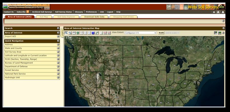
After clicking the green button, you are taken to a page that looks like this:
Credit: Web Soil Survey (2024)
- Notice the Quick Navigation links on the left-hand side of the page.
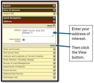
- You can enter an address, state and county, latitude and longitude, or other identifying information to find a place of interest. If you are interested in your home property, it may be easiest to use the Address link and enter your home address.
- In this case, click on Address and enter the address of the property you are interested in. Then click View.
Credit: Web Soil Survey (2024)
Zoom in to a More Defined Area of Interest
- After you click View, you will be taken to an aerial image of your area of interest. In this example, the area of interest is a farm in Hillsborough County, Florida.

Credit: Web Soil Survey (2024)
2. Notice the buttons on the top left of the aerial image. They allow you to zoom in, zoom out, pan the screen (move left, right, up, down), measure distances between points, and other actions.

Credit: Web Soil Survey (2024)
3. You can click on the second-to-last button that has a picture of a rectangle and the letters AOI under it. This will allow you to then use your mouse cursor to draw a rectangle around a specific area on the map that you are interested in. For example, you may be interested in siting a septic system for wastewater treatment from your home and want to check soil properties of a specific location on the map, such as your backyard, etc.
4. After drawing the rectangle on the map, the screen will zoom in to that area.
Learn about Your Area of Interest
- Notice the yellow navigation tabs at the top of the map that say Soil Map, Soil Data Explorer, etc.
- Click on Soil Map.
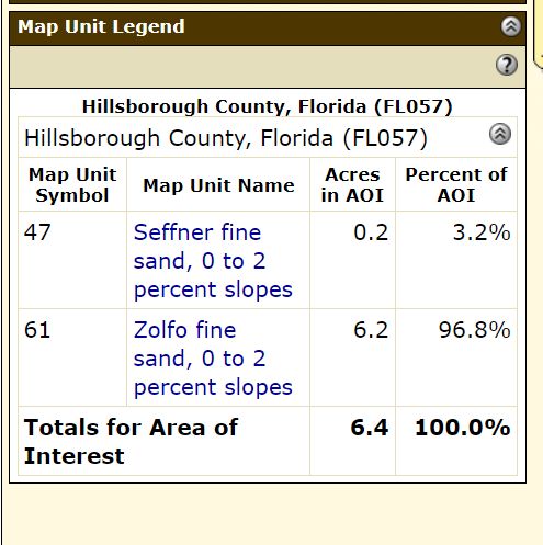
- A legend will appear on the left of your map that lists the soils in your Area of Interest. In the case of the example here, there are two soil types: the Seffner fine sand and the Zolfo fine sand.
Credit: Web Soil Survey (2024)
4. At this point, you can click on any of the Map Unit Names in blue to get basic information about each soil, or you can get more detailed information about soil uses if you go to the next step.
The Soil Suitabilities and Limitations for Use
- Click on the yellow Soil Data Explorer tab.
- Click on the yellow Soil Suitabilities and Limitations tab.
- Notice all the options to explore in the left-hand navigation box. These are categories of potential uses for your land (Building Site Development, Construction Materials, etc.). Clicking on one of the options will show the suitability and limitations of each soil in your area of interest for a given application.

Credit: Web Soil Survey (2024)
4. In this example, we clicked on Sanitary Facilities and then Septic Tank Absorption Fields.
5. At this point, you can click on View Description to read text about that given soil use and how soils are rated for that use. You can then click on View Rating to see how your soils rate for that use.
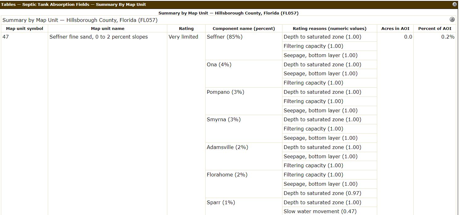
6. After you click on View Rating, scroll down and see how each soil in your area of interest rates for the use category you chose (septic system absorption fields in this example).
7. In this example, we see that the Seffner fine sand has a rating of Very Limited for septic system absorption fields. The reasons for this are given in the table and include things such as depth to saturated zone, filtering capacity, and seepage. The numeric values given in the rating reasons can range from 0.0 to 1.0, with values closer to zero meaning the soil is well-suited for a use and values closer to 1.0 meaning the soil is poorly suited for a use. In this example, the Seffner fine sand has a value of 1.0 in almost all cases, meaning it is poorly suited for septic tank absorption fields.
Credit: Web Soil Survey (2024)
Learn about Soil Properties and Qualities
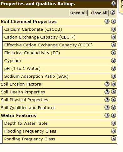
- Click on the top yellow navigation tab that says Soil Properties and Qualities. Many other soil properties are found here, and you can click through some of the tabs to see examples. For example, you can click on Soil Chemical Properties to see the pH of soils in your area of interest. This may be helpful if you are planning a vegetable garden or want to know how to select plants for your yard. Additionally, you could click on the Water Features tab to see information about the depth to the water table and how frequently the soil is expected to flood.
- In this example, we clicked on Water Features and then Depth to the Water Table and saw that both the Seffner fine sand and Zolfo fine sand have 76 cm to the water table.
Credit: Web Soil Survey (2024)

Credit: Web Soil Survey (2024)
Conclusions
There are many types of data about soils in the Web Soil Survey that have not been shown by the brief examples here. By exploring the navigation tabs shown in these examples, you should be able to get a good idea of many types of information that can be found. Soil uses include those related to agriculture and horticulture, engineering, construction, sanitary features, wildlife management, and others. Information on how the soils in your area can be used in these various ways can be found by exploring the navigation tabs in the Web Soil Survey.
As you navigate through the Web Soil Survey, you will sometimes see the question mark icon. You can click on that at any time for tips about how to use certain features.

Credit: Web Soil Survey (2024)
For more information, consult the USDA’s guidance document at https://www.nrcs.usda.gov/sites/default/files/2022-09/How-to-Use-WSS.pdf, which provides more detailed examples of the many uses of Web Soil Survey.
Reference
Web Soil Survey. 2024. “Web Soil Survey.” United States Department of Agriculture, Natural Resources Conservation Service. https://websoilsurvey.nrcs.usda.gov/app/