What is a watershed?
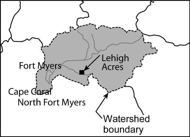
The term watershed is often used in discussions about water quality or flood prevention, but most people do not really understand what a watershed is. The definition of a watershed is based on a concept with which everyone is familiar: "Water runs downhill." A Watershed is a land area whose runoff drains into any stream, river, lake, and ocean. Watershed boundary (e.g., Figure 1) is the divide separating one drainage area from another. Watersheds may be as small as the portion of a yard draining into a mud puddle or as large as the Mississippi River Basin, which drains 1.2 million square miles. Terms like catchment or drainage basin are also used to refer to watersheds.

Credit: Adapted from USEPA (2003)
Where do we find watersheds?
All land area is part of a watershed. Irrespective of whether we live in Florida or any other state or country, we all live in a watershed. You can find the watershed in which you live by browsing a map and looking for the stream located closest to you. If you trace the stream upward to its beginning you will reach the headwaters, whereas if you trace it downward you will eventually reach a larger stream or river, a lake, or the Atlantic Ocean or Gulf of Mexico.
How does a watershed function?
As water flows downhill in small to progressively larger streams and rivers, it moves over land and provides water for urban, agricultural, and environmental needs. The watershed community is made up of everyone who lives there plus all other animal and plant life. The community of humans, plants, and animals depends on the watershed and influence it in some way. Flowing water carries organic debris and dissolved organic matter that provide food and shelter for aquatic life. At the same time, water may also carry pollutants like motor oil, fertilizers, and pesticides. Numerous activities in a watershed have the potential to degrade water quality. There is no "pure" water in nature; all water is "polluted" to some extent. Even in pristine watersheds where water quality is not affected by humans, "natural" pollutant sources are abundant. These include sediment from stream bank erosion, bacteria and nutrients from wildlife, and chemicals deposited by rainfall.
A watershed has five important functions:
- It collects water from rainfall;
- It stores water of various amounts and for different times;
- It releases water as runoff;
- It provides diverse sites for chemical reactions to take place; and
- It provides habitat for flora and fauna.
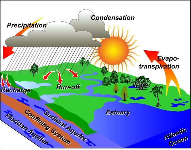
The first three functions are physical in nature and are termed hydrologic functions (Figure 2). The last two are the ecological functions. Human activities affect all the functions of a watershed. For example, when buildings and other impervious areas such as parking lots cover the ground, infiltration decreases and most of the water runs off into collection ditches where stream channel erosion may occur. Furthermore, reduced infiltration may result in less recharge of the groundwater stored in aquifers which supply more than 90% of Florida's drinking needs. With both urban and agricultural land uses, chemicals such as fertilizers and pesticides can mix with rain entering the soil and may reach groundwater, causing pollution of public and private wells.

Credit: Modified from SFWMD (2004)
Florida's Watersheds
Florida's watersheds are unique. Before 1845, much of the state was considered to be swampland because it was naturally covered with water at least part of the year. Florida was thought to have too much water. Beginning in 1845, several engineering programs were initiated to:
- Drain the swamps to make way for houses and farming;
- Cut canals to facilitate drainage and to make navigation faster and safer; and
- Hold back flood water.
With continued drainage the focus has shifted from "having too much water" to currently not having enough water in several watersheds of Florida. While drainage and flood control are still issues in several watersheds, new problems related to water have emerged in most watersheds. These include mainly water supply planning and surface and groundwater quality issues.
While drainage and flood control are still issues in several watersheds, these concerns have been overtaken by water supply planning and surface and groundwater quality issues.
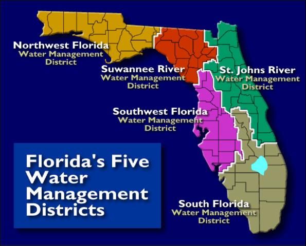
For the purposes of water supply planning and water quality protection, Florida has been divided into five large basins:
- Northwest;
- Suwannee River;
- St. Johns River;
- Southwest; and
- Kissimmee-Everglades (Figure 3).
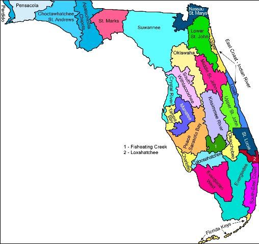
To manage these regions, five "Water Management Districts" were created with similar names, except that the Kissimmee-Everglades District was called the South Florida Water Management District (Figure 3). The soils, vegetation, wild life, and climatic conditions for these basins vary considerably from Suwannee watershed in the north to the Everglades watershed in south (Figure 4).

Credit: SFWMD (2004)

The Northwest region has the largest number of rivers and streams among the five basins. Several major rivers such as the Apalachicola cross the region on their way to the Gulf Coast. More than 70% of the region is forested (including forested wetlands). Barring some water supply and quality problems (e.g., the Choctawhatchee-St Andrews watershed) (Figure 3), most of the region currently has sufficient water supply and the water is of good quality.
Watersheds in the Suwannee River basin cover 7640 square miles in north central Florida. This region is the least-populated in Florida so its natural resources are least impacted by human activities. The headwaters of the Suwannee River are located in the Okefenokee Swamp in Georgia. The river flows south across the Northern Highlands and into the Gulf Coast lowlands, eventually discharging into the Suwannee River Estuary and Gulf of Mexico. The water supply in the watersheds is sufficient to meet current and projected demand, although demand is increasing due to the needs of a growing population, industry, and agriculture. Surface water quality in the basin has been minimally impacted in most watersheds, but it is fair to poor in a few watersheds such as the Fenholloway River drainage basin where it has been affected by industrial discharges. Ground water is of good quality in most of the watersheds except for the Middle Suwannee River (Figure 4), which has an elevated nitrate-nitrogen concentration.
Watersheds within the St Johns River region include the entire St Johns River, Nassau River, Indian River Lagoon and northern coastal basins, and part of the St. Marys watershed. The St. Johns River is the longest river located completely in Florida. Most of the population within these watersheds is found in Duval (Jacksonville) and Orange (Orlando) counties, each of which is growing at a fast pace. Surface and ground water quality varies from good to poor within the region. Water quality in several watersheds, including the Upper St Johns River, has improved due to adoption of agricultural and urban Best Management Practices (BMPs).
The Southwest Florida region contains 11 main watersheds that have been aggregated into larger ones such as the Peace-Myakka-Sarasota Bay watershed (Figure 4.) This region is home to several estuaries of national importance such as the Tampa Bay estuary. Major land uses in Southwest Florida watersheds include agriculture (31%), urban (21.5%), and forest and wetlands (37.4%). The region has experienced a dramatic growth in urban areas that has impacted the water supply as well as water quality. The region's western coastline includes 13 rivers and several streams and waterways. Point and nonpoint pollution sources, such as urban and agricultural stormwater runoff, septic tanks, and heavy industries, have adversely impacted river water quality, while water withdrawals from the watershed have reduced river flow. Comprehensive water conservation efforts are underway to help meet the projected 30% water demand increase by 2020 (compared with 1990).
The Kissimmee-Everglades region (also known as the South Florida Water Management District) is home to water bodies of national importance such as Lake Okeechobee and the Everglades which is also known as the "river of grass." There are two main watersheds in this region: the Big Cypress watershed (also known as the Everglades West Coast Basin) and the larger Okeechobee watershed that spans from the Kissimmee River in the north to Florida Bay in the south. For planning purposes, several Kissimmee-Everglades watersheds (Figures 2 and 3) have been combined to form:
- Kissimmee Basin;
- Upper East Coast (St. Lucie);
- Lower East Coast (Loxahatchee, Southeast Coast, and Everglades); and
- Lower West Coast (Caloosahatchee and Big Cypress).
The region accounts for 40% of Florida's population and 31% of the total land area. The world-renowned Everglades, the largest subtropical wetland in the US, covers 3480 square miles. The historic Everglades system, spanning from the south shore of Lake Okeechobee to the mangrove estuaries of Florida Bay, has been reduced to half of its original size to accommodate the drainage and development required by south Florida's ever increasing human population. The region is currently receiving national attention due to the initiation of the Comprehensive Everglades Restoration Plan (CERP), the largest environmental project in the world. The CERP was started in September 2000 to increase water storage and supply for the natural system, humans, wildlife, and agriculture in central and south Florida. Water supply in the Big Cypress and Okeechobee watersheds is expected to increase considerably.
Areas where water resources are currently critical or are projected to be critical during the next 20 years are required by Florida law to be declared Water Resources Caution Areas (WRCA). Much of the Kissimmee-Okeechobee region has been given this designation.
Currently, all of the Upper and Lower East Coast is designated as a WRCA. Both point and nonpoint sources of pollution have impacted surface water quality within the watershed. Although virtually all point source discharges have been controlled, inadequately treated stormwater runoff from urban and agricultural areas continues to have adverse impacts on surface water quality. Ground water quality in the region is variable and is susceptible to pollution in some places due to chemicals from urban and agricultural areas or salt-water intrusion. Throughout the Kissimmee watershed, the water quality of the surficial and the Floridan aquifer system is good.
Watershed Management, Education, and Stewardship
Florida faces difficult challenges regarding watershed resource management. The current pressures that humans place on these watersheds are already causing stress on the environment. Florida's population is expected to grow by 54% from about 13 million in 1990 to 20 million by 2020. Increasing population poses great challenges in the area of managing water resources within a watershed.
Watershed management involves three main activities:
- Rehabilitation of abandoned and misused lands that export excess sediment, chemicals, or ill-timed runoff;
- Protection of natural and sensitive areas to avoid having to rehabilitate them; and
- Enhancement of water resource characteristics.
These three activities only classify broad goals and are subject to large variations. For example, a given practice may achieve one or all of the goals. The practices that protect, enhance, or rehabilitate a watershed are termed as Best Management Practices. A multiple-use approach is needed to achieve sustained, integrated watershed management. Several watershed management programs have been undertaken by Florida's Water Management Districts. For example, SWFWMD has a Comprehensive Watershed Management initiative (CWM) that manages water resources by evaluating interconnected systems of the watershed located within the region. The four primary goals for the CWM program are:
- Identify and prioritize existing and potential water resource issues within the District;
- Develop strategies for remedial or protective actions to address those issues;
- Implement the strategies; and
- Monitor their effectiveness.
Protection of water, land and vegetation requires preventive measures that can be achieved through watershed planning and watershed stewardship programs. Watershed planning is a process in which communities can make better choices about future growth. The units of watershed planning are watershed boundaries. Watershed stewardship programs involve developing watershed educational programs for the residents of the watershed to facilitate the specific watershed restoration needs.
Several such programs have been developed nationally by the partnerships between University Extension Services, Sea Grant, Agricultural Industry Groups, Watershed Councils, Soil and Water Control Districts, federal and state agencies, and non-profit groups. Examples of such programs include: The Watershed Stewardship Education Program (WSEP) at Oregon State University; Center for Watershed Stewardship at Pennsylvania State University; Forest, Rangeland and Watershed Stewardship at Colorado State University; and Master Watershed Steward Program at University of Alaska Extension Service.
The specific goals of these programs vary depending on the watershed issues. For example, the goal of Oregon State University WSEP program is to increase the capacity of watershed groups and community members to identify and address water resource issues at local levels. Given the changes in Florida's watershed due to urbanization, there is a need to develop a collaborative educational program at the UF/IFAS Extension. Such a program will result in greater understanding and appreciation of the watershed issues and enable both urban and the agricultural communities in Florida to take sound decisions for managing Florida's water resources and economy.
References
Black, P. E. 1997. "Watershed functions." Journal of The American Water Resources Association, 33(10): 1–11.
Brooks, K. N., P. Ffolliott, T. John, H. M. Gregersen. 1991. Hydrology and the Management of Watersheds. Ames, Iowa: Iowa State University Press.
Florida State University. 1998. Water Resources Atlas of Florida. Florida State University, Tallahassee, FL 32306.
South Florida Water Management District. 2004. Florida's Five Water Management Districts. http://www.dep.state.fl.us/secretary/watman/ (June 2016).
South Florida Water Management District. 2004. Hydrologic Systems Modeling. http://www.sfwmd.gov/org/pld/hsm/hsm.html.
US EPA. 2003. Surf Your Watershed. US Environmental Protection Agency. http://www.epa.gov/surf (June 2016).