Introduction and Purpose
Residential construction activities can drastically alter the physical, chemical, and biological properties of soils, thereby affecting the growth and performance of landscape plants. Typical urban construction activities such as land clearing, use of heavy equipment, and import of fill soils negatively affect soil properties and lead to problems with plant establishment, growth, and aesthetic quality. Assessment of soil conditions before landscape installation can help to (1) identify and ameliorate problems that may affect plant growth and (2) select the most appropriate landscape plant species. The target audience for this publication includes homeowners, turf managers, and lawn care service companies.
Soil Assessment
Preplant soil assessment allows land managers to characterize soil properties and identify major problems that may affect plant growth and quality. After completing the soil assessment, you should have answers to the following questions:
- What is the soil texture?
- What is the soil pH/fertility status?
- What were the natural soil conditions?
- How disturbed is the soil?
- What is the extent of soil compaction?
- Are there soil drainage problems?
- Is there a salinity issue?
What is soil texture?
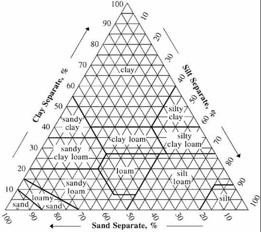
Soil texture is the relative proportion of sand, silt, and clay particles. In general, coarse-textured or sandy soils have more sand, moderate-textured or loamy soils have more silt, and fine-textured or clayey soils have more clay. In Florida, surface soils tend to fall in the sandy, loamy sand, or sandy loam textural classes, which are located in the bottom left-hand corner of the textural triangle (Figure 1). Soil textural class can be determined in the laboratory or estimated by a trained soil scientist using a "feel" method. Knowledge of the soil texture can provide clues about other important soil properties, such as water-holding capacity and fertility. For example, sandy soils are often well-drained and have low fertility, organic matter, and water-holding capacity.

Credit: USDA-NRCS
What is the soil pH/fertility status?
Soil pH affects the growth and quality of landscape plants by influencing nutrient availability and soil microbial processes. In acidic soils, the availability of plant nutrients such as potassium (K), calcium (Ca), and magnesium (Mg) is reduced, while the availability of potentially toxic elements such as aluminum (Al), iron (Fe), and zinc (Zn) is increased. In alkaline soils, iron, manganese (Mn), zinc, and boron (B) are commonly deficient. Maximum nutrient availability of most nutrients is greatest between 6.0 and 7.0 soil pH.
The soil pH can be determined by sending a soil sample to a reputable testing laboratory such as the UF/IFAS Extension Soil Testing Laboratory (ESTL). The UF/IFAS ESTL website is https://soilslab.ifas.ufl.edu. Some UF/IFAS Extension offices also test soil for pH, and you can locate your local UF/IFAS Extension office at https://sfyl.ifas.ufl.edu/find-your-local-office/. For more information about soil sampling and testing (including instructions on how to take a soil sample), see EDIS publication SL281/SS494 Soil Sampling and Testing for the Home Landscape or Vegetable Garden (https://edis.ifas.ufl.edu/ss494).
The best advice regarding soil pH is to choose landscape plants suited for the natural pH of your landscape soil. There are soil additives that can raise or lower the pH of soils; however, the effects of these materials are often very short-lived. In addition, if your soil pH is within 0.4 of a pH unit of the ideal range, adjusting the pH will probably not improve plant performance. For more information about adjusting the pH of acidic and marginally alkaline soils, see EDIS publication SL256/SS480 Soil pH and the Home Landscape or Garden (https://edis.ifas.ufl.edu/ss480).
What were the natural soil conditions?
Construction activities often lead to significant changes in soil properties, making it difficult to determine the properties of the natural soil that existed before construction. Information about the native soil conditions may be useful with regard to site suitability and limitations. While some topsoil may be removed from sites before construction, the lower soil horizons may still be present or may have been incorporated into fill soil placed on the site after construction was completed. The soil survey, available either in print form or through the Web Soil Survey at https://websoilsurvey.nrcs.usda.gov/app/HomePage.htm, contains a description of the soil series and profile, general information about site suitability for various activities, as well as specific physical and chemical properties of the soil.
How disturbed are the soils?
During residential construction, topsoil is often removed from the site, exposing the subsoil. Topsoil material may be stockpiled for future use at the site or removed completely.
Construction-related activities, such as use of heavy equipment or fill soil materials and installation of impervious surfaces, can alter the physical properties of the exposed subsoil. As a result, soil may be (1) minimally disturbed (soil profile disturbed but not compacted), (2) moderately disturbed (soil profile disturbed and soil compacted), or (3) completely unusable (soil characteristics or compaction level will inhibit plant growth). It is a good idea to take a soil core (Figure 2) or dig out a vertical slice from the disturbed soil; existing construction holes or trenches can be useful for this purpose. Lay the soil core out on a flat surface, and compare the existing disturbed soil to the description of the native soil indicated on the site soil survey. This comparison will give you an idea of the kind of disturbance the site received during construction activities.

Credit: Amy Shober, UF/IFAS
What is the extent of soil compaction?
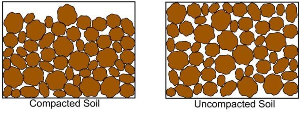
Compacted soils provide a stable foundation for homes, but they are not ideal for plant growth and water infiltration. In fact, it may be nearly impossible to establish plants in compacted soils. Soil compaction reduces the total number and size of air-filled pores, which are critical in providing the plant roots with oxygen (Figure 3). Compaction can also increase resistance to root penetration, which can cause poor/shallow rooting and thus poor plant growth. There is often an increased need for irrigation and fertilization in compacted soils because of the limitations to plant growth encountered under compacted conditions. Poor plant growth in compacted soils can also require replacement of dead or declining plant material, often at additional cost to the homeowner or landscape professional.

Credit: Geoff Denny
The extent of soil compaction can be determined by measuring soil bulk density. Soil bulk density is the mass of dry soil per unit volume (e.g., grams per cubic centimeter) and accounts for the spaces between the soil particles (pore space) as well as the soil solids. Soils with a high proportion of pore space have low bulk densities and vice versa. Bulk density may range from normal (approximately 1.4 g/cm3) to extremely packed (2.2 g/cm-3) in urban mineral soils. Soil bulk density can be estimated in the field using the following steps (adapted from Lichter and Costello 1994):
- Weigh bucket or container.
- Dig a 12-inch-deep hole, and place all of the soil in container.
- Determine the volume of the hole: Line the hole with a plastic bag and fill the bag with water; then measure the volume of water in the bag.
- Place soil in an oven for 24 hours at 180°F–200°F until completely dry (or dry in a microwave for 2–4 minutes), then cool for 1 minute until it reaches a constant weight.
- Weigh the dried soil.
- Calculate bulk density using the following equation: Bulk density = (weight of dry soil – weight of bucket or container) / volume of water.
If the soil bulk density is higher than documented compaction threshold levels (Table 1), tillage methods or organic matter may be needed to reduce compaction and improve rooting. For more information about how to manage compacted soils, see EDIS publication SL317/SS529 Soil Compaction in the Urban Landscape (https://edis.ifas.ufl.edu/ss529).
Are there soil drainage problems?
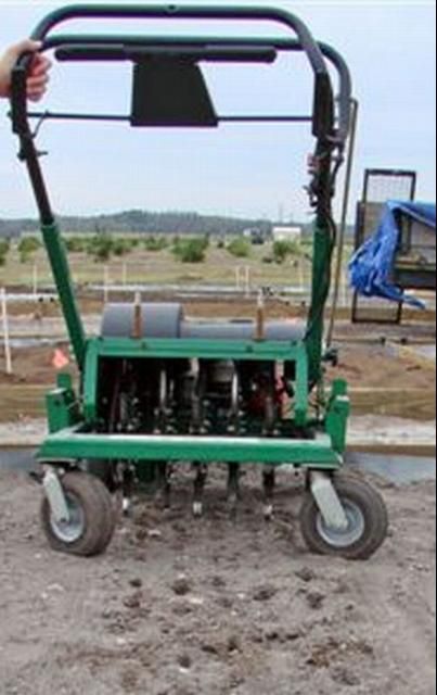
Soil drainage problems can be a result of natural topography, soil grading during construction, or existing soil compaction. Problem areas can be identified by observing (1) low-lying areas in the landscape, (2) areas where water collects after a rain, and (3) areas that remain wet after the surrounding soil has drained. In cases where natural topography or poor soil grading activities result in poor drainage conditions, re-grading the site may be necessary. Alternatively, the landscape design should take moderately wet or dry areas into account by choosing plant species tolerant of these conditions. Actions, such as tillage and adding organic amendments, may alleviate drainage issues if compaction is the cause. Additionally, aeration with a soil core aerator (Figure 4) can help to moderately increase drainage in some situations.

Credit: Gitta Shurberg
Is there a salinity issue?
High soil salinity may be a naturally occurring problem in coastal areas. However, the use of saline irrigation water (such as well water in coastal areas or reclaimed water) or excessive fertilization may also lead to salt accumulation. High salt concentrations can cause soil structure problems, Mg and K deficiency, chloride toxicity (leaf burn), and root desiccation. Plants vary in their tolerance to soil salinity; therefore, it is important to assess the salinity of your soils so that you can correct the problem or select appropriate plant material.
Salinity problems can be diagnosed by testing the electrical conductivity (EC) of the soil. Soil EC can be measured directly in the field with a special probe or in the lab (available by special request at the UF/IFAS ESTL). Soil EC will increase with increasing salt concentration. While the EC test can indicate a salt problem, it cannot provide information about the specific salts present in the soil. For more information about the methods for determining soil salinity and options for controlling or dealing with soil salinity, see EDIS publication SL262/MG447 Soils and Fertilizers for Master Gardeners: Tackling Soil Salinity Problems in the Home Landscape (https://edis.ifas.ufl.edu/mg447). For information on salinity issues with reclaimed water, see EDIS publication SL340/SS545 Reclaimed Water Use in the Landscape: Managing Salinity, Sodicity, and Specific Ions in Sites Irrigated with Reclaimed Water (https://edis.ifas.ufl.edu/ss545).
Landscape Design Following Soil Assessment
Once the assessment is complete, you are ready to start your landscape design. Corrective actions should be considered to remedy major problems, such as soil compaction, so that the landscape design has the best chance of resulting in healthy plants and low maintenance. The simplest design strategy may include choosing plant species that are tolerant of the soil conditions (e.g., pH, salinity, drainage).
References
Brady, N. C., and R. R. Weil. 2002. The Nature and Properties of Soils. NJ, Prentice Hall: Upper Saddle River.
Lewis. D. T. 2008. "Bulk Density." In Encyclopedia of Soil Science, edited by W. Chesworth, 74. Dordrecht, Netherlands: Springer.
Lichter, J. M., and L. R. Costello. 1994. "An Evaluation of the Volume Excavation Technique for Measuring Soil Bulk Density." Journal of Arboriculture 20(3):160–164.
Urban, J. 2008. Up by Roots: Healthy Soils and Trees in the Built Landscape. Champaign, IL: International Society of Arboriculture.