Summary
Lake Okeechobee is a large natural lake that is a central feature in the south Florida regional ecosystem. It now is encircled by a dike, and it has become the main surface water storage feature for water supply in south Florida and for the Comprehensive Everglades Restoration Program, or CERP. The CERP is a multi-billion dollar federal-state project to restore the Everglades and ensure the water supply for the growing human population of southeast Florida. The CERP also is intended to reduce harmful releases of fresh water from Lake Okeechobee to estuaries on the east and west coasts of Florida. The extent to which the CERP is successful in achieving its restoration goals depends in part on how much water can be stored in Lake Okeechobee each rainy season for subsequent use in hydrating the Everglades in the dry season. The amount of water stored in Lake Okeechobee and how it is released also affects the ecological health of the lake and the east and west coast estuaries that are connected to the lake by man-made canals.
To ensure that water levels in Lake Okeechobee do not weaken the Herbert Hoover Dike—the levee that almost completely surrounds the lake and that is the lake's main flood protection mechanism—the US Army Corps of Engineers (henceforth "the Corps") follows a regulation schedule, a set of rules stipulating when water must be released from the lake at a given time of the year and how much water to release each time. More water is released just before the summer rainy season, and less is released going into the winter dry season.
Regulation schedules are not perfect, and sometimes they cause controversy. In the case of Lake Okeechobee, the major controversy is about releases of lake water into the St. Lucie and Caloosahatchee estuaries to prevent failure of the Herbert Hoover Dike. Large amounts of fresh water as well as harmful nutrients are transported from the lake to the estuaries during those flood-control releases. This can cause harm to the estuaries, which rely on a delicate combination of salt and fresh water to stay healthy, and which can develop noxious blooms of algae when nutrient levels become high. Yet flood water from the lake must be sent to the estuaries because of major physical constraints in the way the region's flood control system is built, as well as legal constraints to sending phosphorus-rich water south to the Everglades.
This article provides a history of Lake Okeechobee regulation schedules and an overview of the risks, constraints, and trade-offs that the Corps must consider when deciding to release flood water from the lake.
The Historical Lake and Its Surroundings
Lake Okeechobee is a 730-square-mile natural lake located south of Orlando and almost immediately west of Stuart. Historically, the lake was the major source of water to the Everglades. The lake and surrounding wetlands filled with water in the rainy season, and this water slowly flowed to the south, providing water to the Everglades in the dry season.
Before Europeans settled in Florida near the turn of the 20th century, water flowed into the lake along its northeastern shore from meandering rivers and wetlands and exited by numerous small creek channels to the south and southeast toward Florida's west coast via a wetland and lake system that no longer exists. The lake's boundaries naturally fluctuated with the wet and dry seasons (Figure 1). After heavy rain events and large volumes of water inflow, lake levels sometimes rose to over 20 feet above sea level, spread out over the surrounding wetlands, and increased the size of the lake considerably. Outflows to the Everglades happened in a broad sheet flow at the southern end, into a vast forest of pond apple trees, then into the Everglades sawgrass plains.
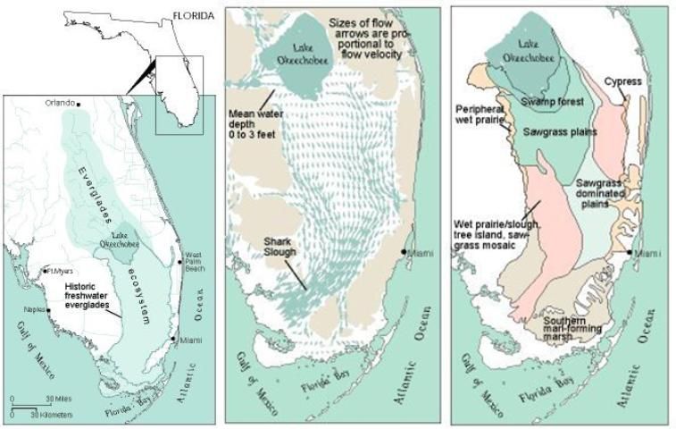
Credit: US Geological Survey
From Natural Lake to Reservoir
When European settlers came to Florida and developed towns and cities along the state's lower east coast, they viewed the Everglades as a useless swamp. A series of developers attempted to drain parts of it to make it suitable for human uses like agriculture. Many early attempts were failures, but eventually much of the northern Everglades was drained by ditches that directed water flow south and east toward the ocean. Developers also constructed a rudimentary earthen levee to hold back water at the south end of Lake Okeechobee. However, catastrophic hurricane-related floods in the early and mid-1900s caused the lake to overflow its southern levee, drowning thousands of people and destroying communities and tremendous areas of agricultural land.
Portions of a more substantial dike system around the lake began to emerge in the 1930s to 1950s. Herbert Hoover spoke when the dike was named and dedicated in 1961. The Herbert Hoover Dike completely encircles the lake except for a portion on the west side where a large wetland from Fisheating Creek flows into the lake. In addition to the dike, the Corps constructed a network of drainage canals that led to compartmentalization of the northern Everglades. The project also resulted in large canals from Lake Okeechobee to the east, connecting to the St. Lucie River and Estuary by a series of gates and locks, and to the west, connecting to the Caloosahatchee River and Estuary (Figures 2 and 3). Smaller canals to the south were constructed mainly to provide water for agriculture and to convey water to the growing urban area along the lower east of the state. Once surrounded by a dike, the lake now functions as a reservoir.
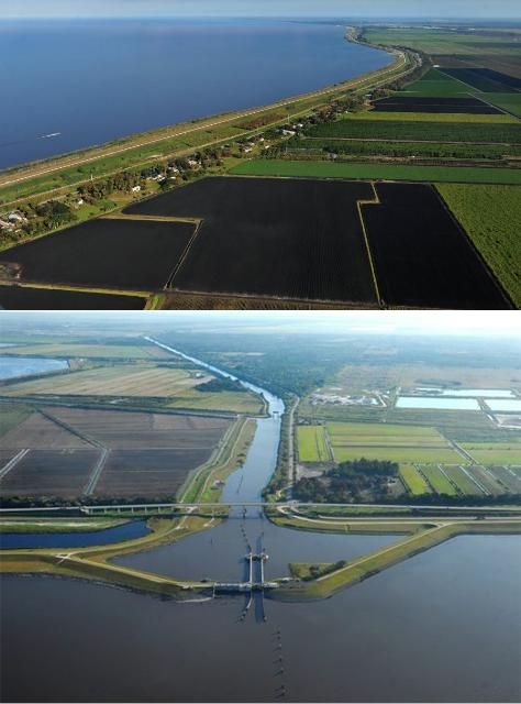
Credit: South Florida Water Management District
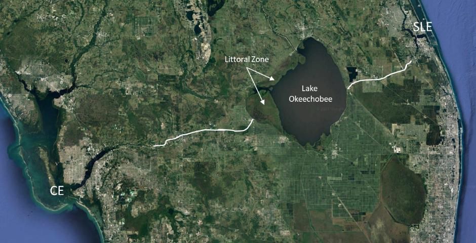
Credit: Google Earth
Managing High Water
One major feature of the Lake Okeechobee reservoir is unusual—in years with heavy rain, the capacity for water to flow in greatly exceeds the capacity for water to flow out. This creates a potentially dangerous situation. Further, the dike around Lake Okeechobee was constructed mostly of soil, with concrete-reinforced structures placed only at the major canal outlets. Building a soil dike on the underlying ground was risky, especially in areas where that ground was largely comprised of fragile peat soil. Designers of the dike knew early on that a large hurricane could create waves that might compromise the dike at high water levels.
In light of this risk, and because south Florida has distinct rainy and dry seasons, the Corps developed a regulation schedule to manage Lake Okeechobee water levels. In the most general sense, this allows the lake to fill up to higher levels just before the winter dry season to ensure adequate water supply for urban and agricultural uses. In spring, water is released to create as much space as possible to hold water before the wet season brings summer tropical storms.
At times lake levels still become dangerously high in the wet season, and the Corps must discharge water at a high volume. Since the Herbert Hoover Dike was constructed, the largest discharges have gone to the St. Lucie and Caloosahatchee Rivers and ultimately to the St. Lucie and Caloosahatchee Estuaries.
The Lake Okeechobee regulation schedule has changed over time, both for the purpose of holding more water for downstream human uses and also to strike a balance that provides options for flood protection, water supply, and estuary health. The regulation schedule must also support the health of a large wetland along the western shore of the reservoir that formed inside the dike after it was constructed.
Confounding the effects of water levels and discharges are the massive amounts of phosphorus that have accumulated in Lake Okeechobee from past inputs from agriculture located north of the lake. Phosphorus is an essential nutrient for crop and other plant growth and also fuels growth of algae and plants in lakes. However, when it reaches high levels it can stimulate harmful algae blooms and have other negative effects mentioned below.
Most of the agricultural phosphorus in Lake Okeechobee now resides in muddy sediments on the bottom of the deepest part of the lake. Wind routinely stirs up this mud and the associated phosphorus. As a result, the middle of the lake is usually turbid and phosphorus-rich, and it sometimes has algae blooms. When water is discharged to the estuaries, it can carry high amounts of phosphorus and possibly seed the St. Lucie Estuary with blooms. The phosphorus in the mid-lake sediments also can harm the lake's own littoral zone.
When lake levels are low, less than 15 feet above sea level, the littoral zone has naturally low concentrations of phosphorus, much like the Everglades, and it can support a diverse mosaic of plants including sawgrass, spike rush, and willow. These provide excellent habitat for many species of wading birds, more than 30 species of fish, and the federally endangered snail kite.
However, having a mid-lake area that is highly polluted with phosphorus creates a risk for the pristine littoral zone habitat. If lake levels rise to the 16-foot range, water from mid-lake mixes with the littoral zone. The associated phosphorus causes cattails to invade the habitat of the aforementioned desirable plants. Dense cattail is not good habitat for birds and other animals, and once it takes over, it takes human intervention such as burning or herbicide to remove. A high lake level can also cause harm to the littoral zone by allowing wave energy to tear up its shoreline and by flooding plants. If birds are nesting in the littoral zone and the lake rapidly rises, their nests are destroyed. There have been years when most wading birds have experienced total nesting failure for this reason.
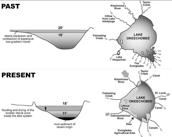
Credit: Karl Havens, UF/IFAS
When the water depth in Lake Okeechobee becomes dangerously high, there are constraints on where water can be sent when it is discharged from the lake. Canals to the south are small and mainly intended to transport water for agricultural and urban uses. Their capacity for moving flood waters is limited. Furthermore, storage areas south of the lake, in particular the Everglades Water Conservation Areas, often are full of water and cannot take more from the lake. Those large areas of the former Everglades also are surrounded by levees that lie right up against lower east coastal metropolitan areas. Filling these areas with too much water puts millions of people at risk from flooding. Some water can make its way through the relatively small canals south of the lake and get all the way from Lake Okeechobee to the ocean, but this also cases harm from phosphorus pollution in places like the Lake Worth Lagoon and Biscayne Bay.
The two options with greatest capacity to take water from Lake Okeechobee are the St. Lucie and Caloosahatchee Rivers, which are fed from the modern-day lake by large, deep canals. The trade-off however, is that when high amounts of Okeechobee flood waters flow from these canals, salinity in the St. Lucie and Caloosahatchee Estuaries can drop to near zero, killing oysters and other organisms that need brackish water to survive. Inflow of nutrient-rich and algae-laden water from the lake also has led to severe blooms of toxic algae in the St. Lucie Estuary and even in the adjacent nearshore waters of the Atlantic Ocean.
In recent decades, further constraints have been placed on the ability of agencies to send water south from Lake Okeechobee when water levels are high. The settlement of a federal lawsuit about phosphorus pollution of the Everglades now strictly limits the amount of phosphorus-laden water that may be discharged to the south, unless the discharged water is treated. However, the capacity of stormwater treatment areas to remove phosphorus is limited by both size of treatment wetlands and the long residence time of water needed to take phosphorus down to legally required levels. Further, if migratory birds are nesting inside water treatment areas, those areas may not be able to take on more water because the Migratory Bird Treaty act generally does not allow flooding of migratory bird nests.
When lake levels are high, all of these risks, constraints, and trade-offs are taken into consideration each week when the Corps decides whether to hold water in the lake or release it. How will a decision affect the dike integrity? How will it affect the health of the littoral zone? How will it impact the estuaries? Are oysters spawning in one of the estuaries but not in the other? This is all information that may in part guide where water is sent. Ultimately, the lake's regulation schedule mandates the amount of water to be released when lake levels rise above a certain point at a particular time of the year. In general, when the regulation schedule requires large flood-control releases, there tend to be fewer risks and constraints when releasing the water to the east and west than when releasing it south.
A More Detailed Look at Lake Okeechobee Regulation Schedules
Several different regulation schedules have existed since the Herbert Hoover Dike was completed. The earliest schedules were controlled by the Everglades Drainage District, and they were focused on controlling flood waters that endangered communities around the lake, as well as providing water for irrigation of crops south of the lake. In 1951, the Corps implemented a formal regulation schedule with distinct regulatory bands, which are lines on a schedule that define maximally acceptable water levels at any particular time in the year. When water levels rise above a particular band, the Corps discharges water from the lake. The volume of the discharges is greater if water levels rise above higher bands in the regulation schedule. The Corps modified the lake regulation schedule in 1954, 1958, 1965, 1972, and 1978. The refinements led to increasingly greater storage capacity and water levels in the lake, and were responses to shortfalls in the amount of water that was available for a growing agriculture industry, especially south of the lake.
After several years had passed, an evaluation of the 1978 regulation schedule by the Corps, the South Florida Water Management District, and the US Environmental Protection Agency concluded that the very high dry-season water levels allowed by the schedule were overly protective of water-supply demands. The high water levels in the dry season were causing large, damaging releases of fresh water to the St. Lucie and Caloosahatchee Estuaries and flooding habitat for plants and birds and other animals in the littoral zone of Lake Okeechobee. Following a federal environmental impact study (EIS), a new regulation schedule called Run 25 was adopted, with the goal of reducing high-volume releases to the estuaries while still meeting requirements of water users. This new schedule was not sufficient to help the lake, and damage from deep flooding continued to occur in the littoral zone.
In 2000, another EIS prompted the Corps to implement a new regulation schedule called Water Supply and Environment, or WSE. Its goal was to meet water supply demands, reduce harmful estuary discharges, and reduce the frequency of deep flooding to the littoral zone. This was attempted by incorporating, for the first time, a proactive "decision tree" into lake operations. This meant that decisions about whether to hold or release water were made based on current water levels, as well as both short- and long-term outlooks of inflow volume. Short-term outlooks were based on whether the tributaries north of the lake were wet or dry. Long-term outlooks were based on climate cycles that influence rainfall in south Florida, in particular the now familiar El Niño Southern Oscillation (ENSO) or another climate cycle, the Atlantic Multi-Decadal Oscillation, or AMO. In an El Niño year, the Pacific Jet Stream is displaced to the south and flows over the Gulf of Mexico, bringing more rainfall to south Florida in winter. In its opposite phase, known as La Niña, that jet stream is farther north across the North American continent, resulting in less rainfall in the dry season. As much as 60 percent of the variation in winter rainfall over the south Florida peninsula can be predicted based on the phase of the El Niño cycle.
Likewise, a warm phase of the AMO climate cycle has historically resulted in greater summer rainfall and up to 40 percent more inflow to Lake Okeechobee than when the AMO is in a cold phase. When the WSE operating schedule was in effect, the Corps used this information to be more aggressive about water releases when a strong El Niño was developing, particularly when coupled with a warm-phase AMO. The WSE schedule was more conservative about water releases when a strong La Niña was developing, particularly when coupled with a cold-phase AMO.
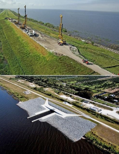
The implementation of the WSE was only mildly successful; the limitation of holding enough water remained a central problem. At the same time, structural repairs to the Herbert Hoover Dike continued to mount. In 2007, the Corps began more than $300 million worth of projects to reinforce the Herbert Hoover Dike that surrounds Lake Okeechobee because of flood risk and safety concerns (Figure 5). Water had begun to seep through the mostly earthen dike following hurricanes and high lake levels in 1998, 2004, and 2005. When the dike rehabilitation project began, a concrete cut-off wall was installed inside the most risky areas of the dike, and water control structures around the lake where seepage was occurring were replaced. Work was initially planned to be done in segments, starting with those determined from geotechnical studies to be at greatest risk of breach.
Credit: US Army Corps of Engineers
In 2013, after completing the construction of a cut-off wall in the highest-risk southern reach of the dike, the Corps began replacing 32 water-control structures around the lake considered to pose the next greatest risk of dike failure. Construction of the remaining cut-off walls then started again, and they are slated to be done before 2025.
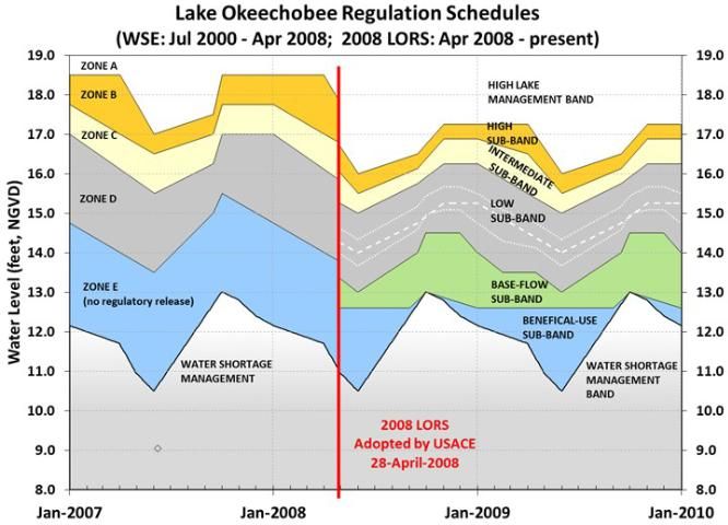
Because the underlying reason for dike rehabilitation was a high risk of structural failure, the Corps conducted an EIS and in 2008 adopted a new regulation schedule called the Lake Okeechobee Regulation Schedule 2008, or LORS 2008. The new regulation schedule is intended to hold the lake at what the Corps considers to be safe levels until dike rehabilitation is complete. As with all the former schedules described above, LORS 2008 has seasonally varying bands identifying highest water levels above which flood-control releases must occur. LORS 2008 also includes a beneficial use band below the flood-control bands, where the SFWMD may recommend sending water out of the lake for beneficial uses. There are many kinds of beneficial uses of water in the dry season. For example, a beneficial use might be a pulse of water sent to the Caloosahatchee River in the dry season to prevent salt water from reaching the Ft. Myers drinking water intake. Other beneficial uses could be releasing water from the lake for irrigation of crops or sending water south to treatment areas where after removal of phosphorus it could be used to hydrate the Everglades.
LORS 2008 has many features that are similar to WSE (Figure 6). Just like the flood-control bands in the WSE, releases of water from the lake in LORS 2008 are determined based on rainfall outlook, the amount of water in tributaries, and multi-season climate outlooks. A major change from WSE is the explicit objective of LORS 2008 to hold Lake Okeechobee at a lower level achieved in part by continual low-volume releases to the estuaries.
Credit: South Florida Water Management District
More specifically, the objective of LORS 2008 is to "maintain a lake level between 12.5 and 15.5 feet," according to the Corps. This is achieved by managing water within bands shown in Figure 6, as follows:
- High lake management band—includes lake levels above 16 feet in advance of the wet season or levels above 17.25 feet during the dry season. Within this band, operations are focused on reducing the lake level and freeing up additional capacity for runoff from future heavy rains. Maximum water releases occur when the lake is in this band.
- Operational bands—these are five sub-bands that guide decisions to balance the needs of all users while maintaining a lake level in the Corps' preferred range of 12.5 and 15.5 feet. Toward the lower end of the range, the Corps relies heavily on input from the SFWMD to assist with water allocations. In the upper bands, regulatory releases often are made to achieve the Corps' desired water levels.
- Water shortage management band—this band includes lake levels below 10.5 feet in advance of the wet season or levels below 13 feet at the start of the dry season. In this band, the Corps typically defers decisions on water releases to the SFWMD.
Consequences of Holding the Lake Lower and Future Options
The current LORS 2008 is 1.25 feet lower than Run 25 and WSE. This equates to, on average, more than 500,000 acre feet of lost storage capacity in the lake. As a result, unless a new regulation schedule restores some or all of that capacity, there may be insufficient water stored in the regional ecosystem to provide all of the environmental and water-supply benefits expected to happen when CERP is complete. This is because, as noted earlier, the lake is the main place in the regional system to hold water in the dry season and then make it available for restoration south of the lake in the dry season. Options to make up for the lost lake storage include surface storage in other reservoirs beyond the capacity in the CERP plan, dispersed storage on land, or underground storage. Or the bands could be raised in a new regulation schedule for Lake Okeechobee.
Storing More Water in the Lake
At this time, the Corps has not announced what, if anything, will be done with the LORS 2008 regulation schedule once rehabilitation of the Herbert Hoover Dike is complete. The main reason for holding the lake low under LORS 2008—to protect a weakened dike—will no longer exist. A recent independent report by the University of Florida indicated that in order to meet the goals of CERP, which include providing water for Everglades restoration and meeting the water-supply demands of a growing population in the lower east coast of Florida, an additional 1.46 to 1.76 million acre feet of storage is needed, beyond what the agencies plan to build in CERP. While a careful evaluation will be required to weigh pros and cons given the multiple features of the region (estuaries, littoral zone, water supply, Everglades), reverting to the prior WSE schedule would increase the lake's ability to store more than 500,000 acre feet of water. That is nearly a third of the "missing" water needed for CERP to meet all of its originally intended restoration objectives.
The Corps will need to conduct a new EIS if it attempts to change LORS 2008. Perhaps when considered in the context of CERP project storage features, managers will be able to identify a schedule that is less harmful to the lake and estuaries than WSE, and more beneficial for sending water south to the Everglades.
Further Reading
Aumen, N.G., and R.G. Wetzel. 1995. "Ecological studies on the littoral and pelagic systems of Lake Okeechobee, Florida (USA)." Archiv fur Hydrobiology, Advances in Limnology, 25, 356 pp.
Enfield, D.B., A.M. Mestas-Nuñez, and P.J. Trimble. 2001. "The Atlantic multidecadal oscillation and its relation to rainfall and river flows in the continental US." Geophysical Research Letters 28: 2077–2080.
Havens, K.E., and D.E. Gawlik. 2005. "Lake Okeechobee conceptual ecological model." Wetlands 25: 908–925.
Havens, K.E., N.G. Aumen, R.T. James, and V.H. Smith. 1996. "Rapid ecological changes in a large subtropical lake undergoing cultural eutrophication." Ambio 25: 150–155.
Johnson, K.G., M.S. Allen, and K.E. Havens. 2007. "A review of littoral vegetation, fisheries and wildlife responses to hydrologic variation at Lake Okeechobee." Wetlands 27: 110–126.
NRC. 2015. Review of the Everglades aquifer storage and recovery regional study. National Research Council of the National Academies, Washington, DC, 57 pp.
SFWMD. 1988. Preliminary evaluation of the Lake Okeechobee regulation schedule. South Florida Water Management District, West Palm Beach, FL, 73 pp (plus appendices).
Steinman, A.D., K.E. Havens, H.J. Carrick, and R. Van Zee. 2002. "The past, present and future hydrology and ecology of Lake Okeechobee and its watershed." Pp. 19–36 in Porter, J.W. and K.G. Porter (eds.), The Florida Everglades, Florida Bay, and Coral Reefs of the Florida Keys: An Ecosystem Source book. CRC Press, Boca Raton, FL.
Steinman, A.D., K.E. Havens, and L. Hornung. 2002. "The managed recession of Lake Okeechobee, Florida: integrating science and natural resource management." Conservation Ecology 6: 17 [online] http://www.consecol.org/vol6/iss2/art17.
Graham, W.D, M.J. Angelo, T.K. Frazer, P.C. Frederick, K.E. Havens, and K.R. Reddy. 2015. Options to reduce high volume freshwater flows to the St. Lucie and Caloosahatchee estuaries and move more water south from Lake Okeechobee to the southern Everglades. University of Florida, Gainesville, FL, 143 pp. https://www.flsenate.gov/UserContent/Topics/WLC/UF-WaterInstituteFinalReportMarch2015.pdf
USACE. 2007. Final supplemental environmental impact statement: Lake Okeechobee regulation schedule. US Army Corps of Engineers, Jacksonville District, FL, 821 pp.
USACE. 2012. Review plan for Herbert Hoover Dike design and construction phases Martin, Palm Beach, Hendry, Glades and Okeechobee Counties, Florida. US Army Corps of Engineers, Jacksonville District, 12 pp (plus appendices).
USACE and SFWMD. 1999. Central and Southern Florida Project comprehensive review study final integrated feasibility report and programmatic environmental impact statement. US Army Corps of Engineers and South Florida Water Management District.
USACE and SFWMD. 2015. Central and Southern Florida Project Comprehensive Everglades Restoration Plan final technical data report aquifer storage and recovery regional study. US Army Corps of Engineers, Jacksonville District, and South Florida Water Management District, 269 pp.
Wossenu, A., and P. Trimble. 2010. "El Niño southern oscillation link to south Florida hydrology and water management applications." Water Resources Management 24: 4255–4271.