Abstract
When contributing to the design, construction, and management of sustainable urban areas, four considerations related to the locations and proximities of conserved lands, built infrastructure, and designed urban ecosystems such as stormwater ponds and ornamental gardens are needed. This publication introduces these considerations and discusses their implications for conservation of native plants and animals. It also discusses the implications of these considerations for increasing the biodiversity and ecological benefits provided by urban landscapes. It addresses the need to recognize and conserve spatial differences in habitat types and explains how the size, shape, and location of conserved lands and urban ecosystems affect plant and animal welfare and movement. For these spatial considerations to yield benefits, they need to be accompanied by proper management of conserved areas and designed ecosystems. Lastly, we introduce the reader to multiple free tools for visualizing and measuring these spatial aspects. It is our hope that this information can empower people to contribute effectively to the design, construction, and management of more sustainable urban areas.
Introduction
This publication is part of the Sustainable Development: What you need to know series and targets those individuals wanting to contribute to, or educate about, spatial arrangement of more sustainable urban developments. It is also useful to those individuals involved in land development projects, including developers, urban planners, and landscape architects. The concepts described in this document stem from the field of landscape ecology and are applicable across spatial scales ranging from individual development projects to state-level planning. Discussing this theory is beyond the scope of this document. However, should one be interested in learning more about the field of landscape ecology, we recommend the following text books: Landscape Ecology in Theory and Practice written by Turner and Gardner (2015) and Essentials of Landscape Ecology written by With (2019).
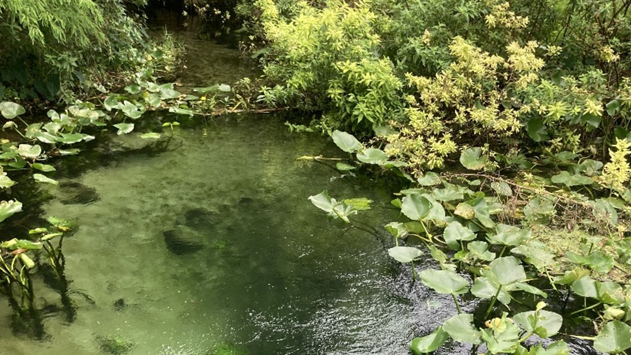
Residential landscapes and low-density housing are currently the fastest growing land cover type in the contiguous United States (Radeloff et al. 2018). According to the 2020 US Census, Florida’s population grew annually by an average of 273,688 new people between 2010 and 2020 (https://www.census.gov/quickfacts/FL). These new residents require housing. The land development required to meet this housing demand contributes to declines in, and fragmentation of, native habitats, impacting native plants and animals as well as the ecosystem services that these native habitats provide (Figure 1). Ecosystem services are the many benefits that humans receive from nature, such as food, clean air, recreational opportunities, and nature-inspired ideas and spirituality. Intentional design and management strategies can reduce the impacts of expanding residential and urban landscapes on native habitats and the ecosystem services that they provide. For instance, conserving natural habitat can improve aesthetics and ensure access to outdoor recreation, helping to improve quality of life. The degree to which developers need or want to mitigate for such impacts varies by jurisdiction and development project.

Credit: Tina McIntyre, UF/IFAS
While zoning rules dictate where a developer can and cannot build, the impacts of this development on native habitats and ecosystem services can be mitigated through conservation and protection of natural areas within and adjacent to proposed development sites. However, the benefits that these conserved natural areas provide may be limited without key spatial considerations such as where these natural areas occur and their size and shape. The same spatial considerations are required for actual developments and the various land covers (defined below) that they contain. The goal of this document is to describe four specific spatial considerations and their importance when balancing land development with land conservation. With these considerations, a reader should be able to look at a map and visualize or measure spatial patterns relevant to the design of more sustainable residential and urban landscapes.
These considerations are:
- Diversity and abundance of different habitat and land cover types
- Size of conserved areas
- Habitat edge vs. core
- Habitat location and connectivity
These considerations are not mutually exclusive. We provide some metrics to use to measure spatial patterns related to these four considerations. We also introduce the reader to some useful tools for making spatial decisions.
Consideration 1: Diversity and abundance of different habitat and land cover types
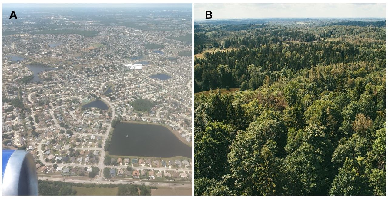
When making decisions about where to develop and where to conserve, one must first understand the diversity of habitat and land cover types that a project site contains. When looking at a map, or an aerial image (Figure 2), one may mistakenly think that natural areas are environmentally similar. However, natural areas can contain multiple types of habitats, even within the same area. That is, natural areas are “spatially heterogeneous.” This spatial heterogeneity needs consideration and protection.

Credit: A. Basil Iannone. B. Free image from pxhere.com. Found at https://pxhere.com/en/photo/43351
By “habitats,” we mean the different types of ecosystems that natural areas contain, e.g., forests, wetlands. By “land cover,” we mean what you would see if you were looking at an area from the sky (Figure 2). Land cover includes natural and human-made land covers such as urban areas, roads, and parks. The United States Geological Survey (USGS) and the Florida Fish and Wildlife Conservation Commission (FWC) have developed standardized categories of land cover at the national and state levels, respectively. Links to these resources are provided in the Resources for Spatial-Based Decisions section of this document.
Wetlands tend to receive greater regulatory protection than other habitat types, such as upland forests. Nevertheless, sustainable development practices require protecting all types of native habitats to ensure the conservation of the different plants and animals that call those habitats home. One strategy to protect all habitat types is to make sure that the relative amounts of each habitat type are similar before and after a development.
Consideration 2: Size of conserved areas
In development projects, setting aside land for conservation rather than development may lead to a loss of profit if doing so means fewer residential, commercial, or industrial areas. What land is set aside is often through development requirements. These financial and legal considerations lead to the reality that not all land can be conserved. Given the limited amount of land that can be conserved, difficult decisions must be made regarding whether it is better to design and plan developments to ensure conservation of fewer but larger areas or more but smaller areas. In general, conserving larger areas, when possible, is better as doing so can help to conserve more habitat types and more plant and animal species. For instance, would you expect to find more habitat types, plants, and animals in the small, isolated areas having tree canopy cover shown in Figure 2A or in the more expansive natural area shown in Figure 2B? The answer is Figure 2B, illustrating the benefit of conserving larger areas when possible.
Nevertheless, conserving more small land areas can be a beneficial alternative when conservation of large land areas is not possible. Small areas in urban landscapes, such as the isolated vegetated areas shown in Figure 2A, can harbor surprisingly high numbers of plant and animal species (Aronson and others 2017). They can also provide important ecological functions and services. For instance, even small areas of tree canopy provide important resting areas for migrating birds, i.e., they serve as stopover habitat (Hostetler and Archer 2021). The UF/IFAS Building for Birds tool (https://wec.ifas.ufl.edu/buildingforbirds/web/home.html) can be used for estimating the benefit to birds of different development designs that vary in the amount of habitat area conserved. In addition, other small pieces of land (e.g., yards, ornamental gardens, stormwater basins) embedded within urban areas can be landscaped to provide habitat for native species. McIntyre, Gutner, and Wilson (2021) discuss landscaping strategies to achieve this goal. Regardless of the size of a conserved area, conserved lands need to have a long-term management plan to prevent their degradation from various urban impacts, such as invasive species, improper stormwater management, and nutrient and pollutant runoff.
Consideration 3: Habitat edge vs. core
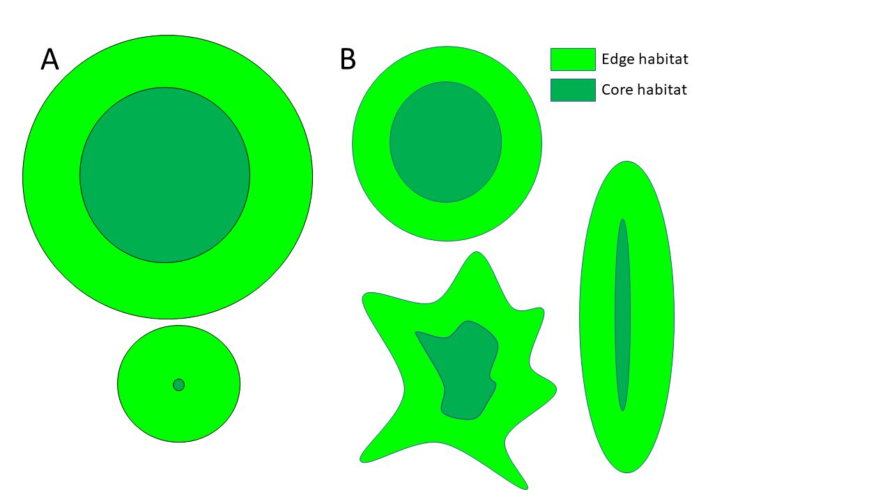
All habitats have edge and core areas (Figure 3). Each area type has very different characteristics, and their relative abundance should be considered when deciding where development and conservation will occur. Edges occur along the periphery of a natural area, whereas cores occur in the center. Edges experience greater effects of neighboring land cover types than do more protected cores. Edges and cores tend to support different communities of plants and animals. Edge areas can support plants and animals that do well in several habitat types and even in disturbed areas. These species are commonly referred to as “generalists.” Core areas are buffered from the effects of nearby land cover types and can support plants and animals that are more sensitive to disturbance and have more precise habitat requirements. These species are referred to as “specialists.” This support of specialist species is why habitat core areas are critical for conservation.
In addition to edge vs. core differences, edge areas can differ from one another in quality depending on nearby ecosystems. For instance, if the edge of a natural area adjoins another natural area, e.g., forests next to wetlands (Figure 2B), it is likely of greater quality, and less stressful, to plants and animals than if it adjoins a heavily urbanized area (isolated vegetated areas in Figure 2A). When edge areas adjoin another natural habitat type, one may find species from both habitats present. In contrast, if the edge occurs next to urban land cover it will experience more disturbance(s). These disturbances include increases in light (for forests), drought conditions, nuisance and invasive species, noise levels, and contaminants, such as air pollution, trash, nutrients in runoff, and yard waste.
The size and shape of undeveloped or conserved areas affect the amount of edge vs. core area (Figure 3). It is possible that a conserved habitat is so small that it effectively contains little to no core (Figure 3A). Such is likely the case for the small, isolated vegetated areas in Figure 2A. Similarly, as habitat areas deviate from a circular shape by becoming thinner or more irregularly shaped, core area decreases, while edge area increases (Figure 3B). A useful metric for determining how a development plan will affect habitat core vs. edge areas is the ratio between the two (core:edge ratio). This ratio can be estimated using Geographic Information Systems (GIS) software (resources provided below in the Resources for spatial-based decisions section). A decrease in this ratio indicates a decline in habitat core relative to more disturbance-vulnerable edge. Total core area and percentage of core area are also useful metrics, although these latter two metrics require that edge width be defined—that is, how far into a habitat is the boundary between edge and core? Edge width will vary relative to the different disturbances that a habitat may face. See Laurance and others (2002) for an example of how edge widths differ in the context of various disturbance types.

Consideration 4: Habitat location and connectivity
Regardless of its purpose, a piece of land is affected by its surroundings. These surroundings need consideration when designing developments and when deciding where to place conserved natural areas. For instance, does a development plan include conserved areas or other green spaces that adjoin another type of natural or semi-natural area? Or do these natural areas and green spaces adjoin a dense urban area? The former situation would be better for conservation purposes, as it would provide an area of habitat that experiences less human-caused stressors.
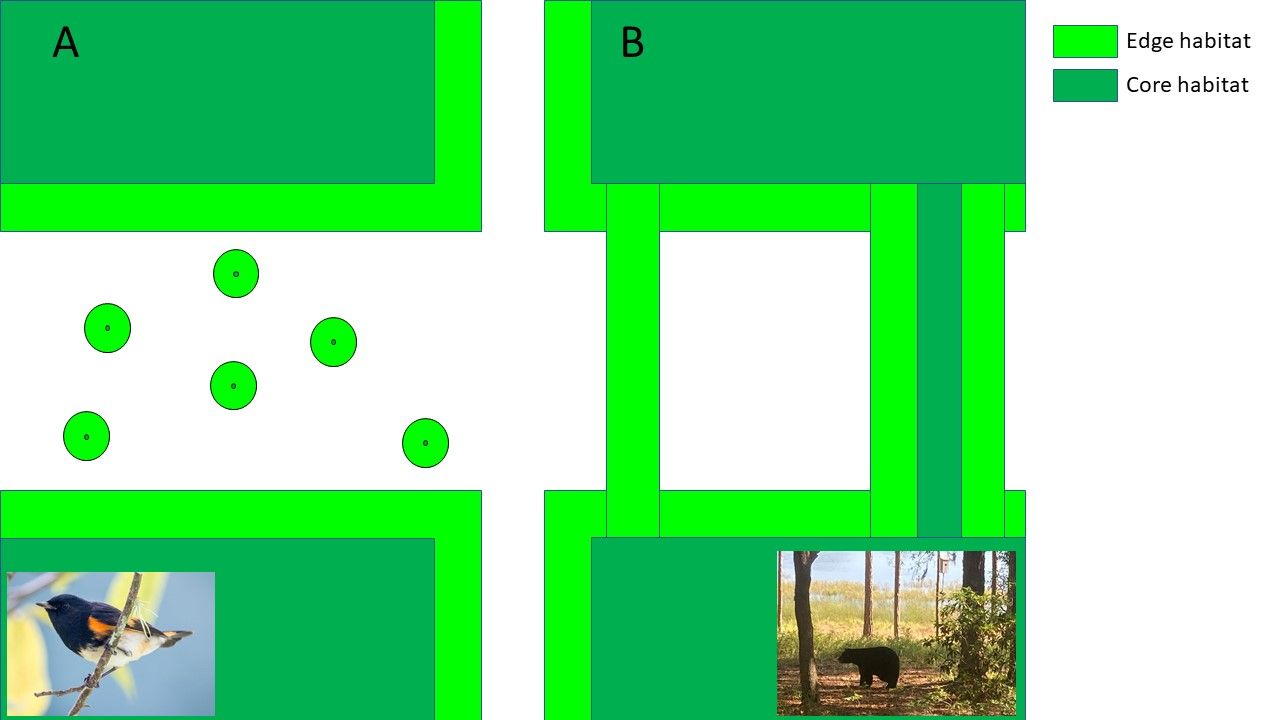
One aspect of location that is critical for conservation is the degree to which a piece of land contributes to habitat connectivity across a larger geographic area. That is, how does the piece of land facilitate movement of plants and animals among other remaining habitats. A fragmented piece of land can enhance habitat connectivity by acting as a stepping stone between larger habitat areas (Figure 4A) or by directly connecting two habitat areas, acting as a “habitat corridor” (Figure 4B). A general rule is that the closer the conserved land is to other habitat, the better, because close proximity will make it easier for plants and animals to disperse among habitat areas. This movement of plants and animals among habitat areas is important to the health and well-being of these organisms because it can help to promote or conserve genetic diversity and long-term persistence of plant and animal populations, thereby helping to mitigate the impacts of habitat fragmentation. Enhanced connectivity among habitats also increases the ability of habitats, and the ecological benefits and services that they provide, to recover from disturbances such as drought, fire, and pests. This ability to recover is referred to as “resiliency.”

Credit: Bird image in A. Becky Matsubara https://madisonaudubon.org/fff/tag/winter; https://creativecommons.org/licenses/by/4.0/legalcode. Bear image in B. Tina McIntyre, UF/IFAS
When setting aside land to enhance habitat connectivity, there are three caveats that should be considered. First, and perhaps most importantly, the degree to which a piece of land improves connectivity is species specific. That is, enhancing habitat connectivity for one species will not guarantee connectivity for other species. For example, while small areas of tree cover within urban landscapes can provide important resting habitat for birds moving among larger habitat areas (Figure 4A), they will be much less helpful to large mammals such as the Florida panther or black bears, which require larger, intact habitat areas connected via wider habitat corridors (Figure 4B). Second, habitat quality matters. For a piece of land to be used by certain animal species, those species must feel safe enough on that land to move through it. Again, safety for one species does not guarantee safety for all species. Third, when designing habitat corridors, width matters. A piece of land that is too thin will not have sufficient core habitat required for some species (Figure 4B). Thin corridors can also increase the movement of unwanted, nuisance and invasive species among conservation areas without providing intended benefits. Habitat corridors that are too thin, or of poor habitat quality can also act as “ecological traps.” This means that the corridor can be detrimental to desired species because the habitat may seem beneficial to the individual animal, but could lack sufficient protection from common urban predators like raccoons and coyotes or even attract them in higher numbers. The prevalence of urban predators is likely due to the loss of the top predators such as the panthers and bears. As top predators are removed from the food web, an imbalance or proliferation of smaller predators or mammals can occur. The same concern regarding ecological traps applies to all urban habitat fragments and land cover types.
Resources for spatial-based decisions
Making decisions about land development design and placement may require quantification of spatial aspects of the landscape. There is a wide range of metrics and tools available to explore and measure spatial patterns of land development decision scenarios. In Table 1 we list a few resources, including places to download spatial data and software, and software packages for visualizing, mapping, and measuring spatial patterns. In addition, we recommend reading the following research papers: “A multi-scale analysis of landscape statistics” by Cain, Riiters, and Orvis (1997) and “Pattern metrics for a transdisciplinary landscape ecology” by Riitters (2019) to learn more about the diversity, and utility, of metrics for measuring various characteristics of spatial patterns. The list provided in Table 1 and these recommended readings are intended to promote independent exploration of other resources.
Final considerations
Four key spatial considerations are needed when designing and planning for development. While spatial considerations are critical for sustainable development, they are not enough by themselves. For instance, good spatially informed decisions need to be accompanied by longer-term management plans. To ensure that conserved areas provide benefits to plants and animals, these areas need to be managed to mitigate against the environmental impacts of urbanization, such as increased pollution and invasive plants. In addition, impacts of development can vary across different habitat types and across different species. It is likely that multiple mitigation strategies may be required to protect the diversity of habitats, plants, and animals found across and/or near a development project.
Each of the spatial considerations described can be applied beyond conservation areas. These considerations can also be applied to components of the developments themselves. Urban development often occurs on agricultural lands or other modified habitats such as pastures or commercial timberlands. These situations, with some imagination, can provide opportunities to incorporate different development components in ways that enhance the ecological value of the area. For instance, how can urban green spaces and/or the many types of designed or engineered ecosystems contained within urban landscapes be placed to enhance habitat connectivity? The UF/IFAS Building for Birds tool (https://wec.ifas.ufl.edu/buildingforbirds/web/home.html) can assist in addressing that question. The amount of planted area in urban landscapes that can contribute to such ecological enhancements can be surprisingly high, approaching 30% in total for some regions, e.g., powerlines, street plantings, ornamental and home gardens, tree canopy, roadside plantings. Of course, maximizing the ecological utility of such areas will require selecting proper plant species that support wildlife and/or provide sufficient cover to facilitate wildlife movement through urban landscapes (McIntyre, Gutner, and Wilson 2021). The Florida Fish and Wildlife Conservation Commission has resources for designing private property as habitat (Cerulean, Botha, and Lagare 2013). The Florida-Friendly LandscapingTM program at UF/IFAS also has resources to help in that regard (https://ffl.ifas.ufl.edu/).
In the end, it is insufficient to consider only how much land to conserve during development. It is also necessary to consider how to conserve areas of different habitat types, and the size, shape, and location of these lands. Such considerations, accompanied by proper natural area management and better design and placement of urban green spaces can contribute to protecting valuable natural resources and the benefits that these resources provide to society.
References
Aronson, M. F. J., C. A. Lepczyk, K. L. Evans, M. A. Goddard, S. B. Lerman, J. S. MacIvor, C. H. Nilon, and T. Vargo. 2017. "Biodiversity in the City: Key Challenges for Urban Green Space Management." Frontiers in Ecology and the Environment 15:189–196. https://doi.org/10.1002/fee.1480
Cain, D. H., K. Riitters, and K. Orvis. 1997. "A Multi-Scale Analysis of Landscape Statistics." Landscape Ecology 12:199–212. https://doi.org/10.1023/A:1007938619068
Cerulean, S., C. Botha, and D. Lagare. 2013. Planting a Refuge for Wildlife. Creating a Backyard Habiat for Florida’s Native Animals, 2nd edn. Florida Fish and Wildlife Conservation Commission and Wildlife Foundation of Florida.
Chen, B., and B. Iannone. 2020. "FRAGSTATS: A Free Tool for Quantifying and Evaluating Spatial Patterns." FOR362/FR431 EDIS 2020 (6):9. https://doi.org/10.32473/edis-fr431-2020
Flenniken, J., S. Stuglick, and B. Iannone. 2020. "Quantum GIS (GIS): An Introduction to a Free Alternative to More Costly GIS Platforms." FOR359/FR428 EDIS 2020 (2):7. https://doi.org/10.32473/edis-fr428-2020
Hesselbarth, M. H. K., M. Sciaini, K. A. With, K. Wiegand, and J. Nowosad. 2019. "Landscapemetrics: An Open-Source R Tool to Calculate Landscape Metrics." Ecography 42:1648–1657. https://doi.org/10.1111/ecog.04617
Hostetler, M. and J. M. Archer. 2021. "Building for Birds Evaluation Tool: Breeding and Wintering Habitat for Forest Birds." WEC372/UW417 EDIS 2017 (1)17. https://doi.org/10.32473/edis-uw417-2017.
Laurance, W. F., T. E. Lovejoy, H. L. Vasconcelos, E. M. Bruna, R. K. Didham, P. C. Stouffer, C. Gascon, R. O. Bierregaard, S. G. Laurance, and E. Sampaio. 2002/ "Ecosystem Decay of Amazonian Forest Fragments: a 22-Year Investigation." Conservation Biology 16:605–618. https://doi.org/10.1046/j.1523-1739.2002.01025.x
McIntyre, T., R. Gutner, and W. Wilson. 2021. "Concepts for Sustainable Landscape Mosaics." ENY1341/EP605, EDIS 2021 (3). https://doi.org/10.32473/edis-ep605-2021
Radeloff, V. C., D. P. Helmers, K. A. Kramer, M. H. Mockrin, P. M. Alexandre, A. Bar-Massada, V. Butsic et al. 2018. "Rapid Growth of the US Wildland-Urban Interface Raises Wildfire Risk." Proceedings of the National Academy of Sciences 115:3314. https://doi.org/10.1073/pnas.1718850115
Riitters, K. 2019. "Pattern Metrics for a Transdisciplinary Landscape Ecology." Landscape Ecology 34:2057–2063. https://doi.org/10.1007/s10980-018-0755-4
Turner, M. G., and R. H. Gardner. 2015. Landscape Ecology in Theory and Practice: Pattern and Process, Second edition. Springer, New York
With, K. A. 2019. Essentials of Landscape Ecology, First edition. Oxford University Press, Oxford, United Kingdom New York, NY
Table 1. List of free resources for spatial data and for visualizing, mapping, and measuring spatial patterns of relevance to sustainable land development.